In this photo provided by the Alaska Army National, Guard Sgt. Mary Miller, a helicopter crew chief, passes a bottle of water to a child while evacuating displaced people from Kwigillingok, Alaska, during recovery operations on Thursday, Oct. 16, 2025. (Joseph Moon/Alaska National Guard via AP)
AP-Damage to remote Alaska villages hammered by flooding last weekend is so extreme that many of the more than 2,000 people displaced won’t be able to return to their homes for at least 18 months, Gov. Mike Dunleavy said in a request to the White House for a major disaster declaration.
In one of the hardest hit villages, Kipnuk, an initial assessment showed that 121 homes — or 90% of the total — have been destroyed, Dunleavy wrote. In Kwigillingok, where three dozen homes floated away, slightly more than one-third of the residences are uninhabitable.
The remnants of Typhoon Halong struck the area with the ferocity of a Category 2 hurricane, Dunleavy said, sending a surge of high surf into the low-lying region. One person was killed, two remain missing, and rescue crews plucked dozens of people from their homes as they floated away.
Officials have been scrambling to airlift people from the inundated Alaska Native villages. More than 2,000 people across the region have taken shelter — in schools in their villages, in larger communities in southwest Alaska or have been evacuated by military planes to Anchorage, the state’s largest city.
Anchorage leaders said Friday they expect as many as 1,600 evacuees to arrive. So far about 575 have been airlifted to the city by the Alaska National Guard, and have been staying at a sports arena or a convention center. Additional flights were expected Friday and Saturday.
Officials are working on figuring out how to move people out of shelters and into short-term accommodations, such as hotels, and then longer-term housing.
“Due to the time, space, distance, geography, and weather in the affected areas, it is likely that many survivors will be unable to return to their communities this winter,” Dunleavy said. “Agencies are prioritizing rapid repairs … but it is likely that some damaged communities will not be viable to support winter occupancy, in America’s harshest climate in the U.S. Arctic.”
The federal government already has been assisting with search and rescue, damage assessments, environmental response and evacuation support. A major disaster declaration by President Donald Trump could provide federal assistance programs for individuals and public infrastructure, including money for emergency and permanent work.
The three members of Alaska’s congressional delegation on Friday sent a letter to Trump, urging swift approval.
The storm surge pummeled a sparsely populated region off the state’s main road system where communities are reachable only by air or water this time of year. The villages typically have just a few hundred residents, who hunt and fish for much of their food, and relocating to the state’s major cities will bring a vastly different lifestyle.
Alexie Stone, of Kipnuk, arrived in Anchorage in a military jet with his brothers, children and mom, after his home was struck by the flooding. They’ve been staying at the Alaska Airlines Center at the University of Alaska, where the Red Cross provided evacuees with cots, blankets and hygiene supplies.
At least for the foreseeable future, he thinks he might try to find a job at a grocery store; he used to work in one in Bethel.
“It’s going to be, try to look for a place and find a job,” Stone said Friday. “We’re starting a new life here in Anchorage.”
Anchorage officials and business leaders said Friday they were eager to help the evacuees.
“Our neighbors in western Alaska have experienced tremendous loss, devastation and grief,” Mayor Suzanne LaFrance said at a meeting of the Anchorage Assembly. “We will do everything we can here in Anchorage to welcome our neighbors and help them through these difficult times.”
State Rep. Nellie Unangiq Jimmie, of Toksook Bay, on an island northwest of Kipnuk, described for the assembly how she rode out the storm’s 100 mph (161 kmh) winds with her daughter and niece.
“We had no choice but to sit in our home and wait to see if our house is going to come off the foundation or if debris is going to bust open our windows,” she said.
It didn’t, but others weren’t as fortunate. She thanked Anchorage for welcoming the evacuees.
“You are showing my people, my relatives, my constituents, even if they are far from home, this is still Alaska land and they’re amongst families,” Jimmie said.
Hundreds gather at Overstreet park in Juneau (James Brooks, Alaska Beacon)
Alaskans came out to protest the Trump administration as part of the nationwide No Kings protest on Saturday, with speeches, songs, and increasingly creative flair — signs, slogans, and costumes, some as inflatable animals like eagles and polar bears.
In downtown Anchorage, protesters filled Town Square Park, and the crowd spilled over to line W 5th and W 6th avenues, where they waved signs and passing cars honked in support.
“It’s a matter of we are losing our rights,” said Keri Lord of Anchorage, dressed in a long cape and crown for the no kings theme. “And we are headed towards fascism, and it needs to stop now.”
Thousands gather at Town Square Park in downtown Anchorage for the second No Kings day protest to denounce the Trump administration and its policies on Oct. 18, 2025 (Photo by Corinne Smith/Alaska Beacon)
There were speeches, chants, poetry and songs. The crowd also showed support for the evacuees of the devastating storm in western Alaska, and urged donations and continued aid for relief and recovery efforts. Non-profits and advocacy groups hosted tables along the Atwood Concert Hall with educational materials and hot coffee.
“It’s great to see so many people come out,” said Karan Gier, matching Lord in a cape and crown, holding a sign reading “No troops in our streets.“ And from all ages. That’s what’s especially wonderful. We’ve seen that all summer, because we’ve been to all of (the protests) all summer long. And it makes your heart feel good to see this. We’re not a silent majority. We are loud.”
At least 25 communities held events throughout the state for No Kings day, including Kotzebue, Nome, Fairbanks, Talkeetna, Healy, Wasilla, Anchorage, Girdwood, Soldotna, Kenai, Homer, Seward, Dillingham, Kodiak, Valdez, Haines, Gustavus, Juneau, Sitka, Ketchikan and others.
Around 45 protesters rallied in Healy, pop. 723, in the Denali Borough of Interior Alaska for the second No Kings day protest on Oct. 18, 2025 (Photo by Michelle Femrite)
Alaskan’s protest signs shared on social media and in Anchorage used humor and satire to mock and condemn President Donald Trump, his cabinet, and recent moves to expand executive powers as authoritarian. Speakers denounced cuts to federal funding and social services such as Medicaid, disregard for the rule of law, and the ongoing government shutdown.
Many protest signs denounced the deployment of U.S. military troops in Democratic-led cities across the country, and the actions of U.S. Immigration and Customs Enforcement violently arresting immigrants and U.S. citizens.
“I love this country, and I think we should be better,” said Kathryn Schild, a life-long Anchorage resident. “I’m appalled at what we are doing to our friends and our neighbors and our loved ones.”
“And this is what we can do, right?” she said. “We have a voice, we can call, we can protest, we can stand up, and we can demand that our government work for us.”
AP- The special delivery arrived in a plastic storage box after a chartered flight in bouncy single-propeller plane. Veterinarian Susan Shaffer Sookram snipped the zip ties securing the lid and greeted the cargo: four dogs, one with a gray collar bearing its name, Happy.
“What a scary ride!” she said. “You made it!”
As officials in Alaska work around the clock on one of the most significant airlift operations in state history — evacuating more than 1,000 people from remote, flood-battered villages on the coast of the Bering Sea — another rescue operation is playing out: getting the dogs left behind to safety, in hopes of later reuniting them with their owners.
The pet shelters closest to the devastated villages are in Bethel, a regional hub around 90 miles (150 kilometers) away by boat or plane.
When Bethel Friends of Canines, a nonprofit that helps rehome animals, learned that 50 to 100 dogs might be abandoned in one of the villages, Kipnuk, it scrambled to charter a plane to evacuate them.
“It costs us $3,000 to do this so and we don’t know how many times we’re gonna have to do it,” organizer Jesslyn Elliott said by phone Wednesday. “We’ve never had a natural disaster to this, like, magnitude. So this is all very, very foreign and new to us. So we’re just kind of winging it.”
The first flight arrived in Bethel on Wednesday night, and more happened Thursday. Dozens of dogs have passed through her kennel since the floods began. The nonprofit had raised more than $22,000 after pleading on Facebook for donations.
The flooding, caused by remnants of Typhoon Halong, has damaged homes in 11 small rural communities, with no more than a few hundred residents, according to FEMA. Many homes cannot be repaired until next summer as winter temperatures and snow are forecast for this month.
Pets were not allowed on the military evacuation flights. State officials have said that the evacuation of people is the priority.
Bethel Friends of Canines received dogs throughout the week as people fleeing their homes arrived by boat and by plane. There are no roads connecting towns in the area.
Many of the pets owners want them back soon, but need time to prepare temporary lodgings in cities like Anchorage and Nome, which are more than 250 miles (400 kilometers) away.
Before the devastating floods, Bethel Friends of Canines typically held 15 to 20 dogs at any one time. Now as many as 15 dogs have arrived on a single flight. Elliott expects most of the additional dogs to stay in Bethel temporarily before being reunited with their owners or extended family that can foster them.
At least eight dogs had been reunited with owners in Anchorage as of Thursday morning, she said.
Homes in affected villages are so damaged that they many not be livable in the winter, emergency management officials said Wednesday, and forecasters said rain and snow could arrive this weekend.
With the human population in Kipnuk shrinking each day, the animal caretakers in Bethel realized they had to act fast, before everyone who knew the dogs was gone.
“There’s going to be nobody left there,” said Sookram, the veterinarian, in a phone interview. “We’re having to kind of accelerate how the animals are going to be leaving places only accessible by, at first, helicopter and now small planes,”
Some of the last people to stay behind and serve the community are teachers. Schools in flooded towns have served as emergency shelters and meeting places through the relief effort.
Back in Kipnuk, the dog with the gray collar, Happy, was found waiting on its owner’s clothes, refusing to move or eat, by teacher Jacqui Lang. She said in a text message that the dog has since been reunited with its family.
She’s one of two or three teachers who helped wrangle the pets to be loaded at the airstrip, according to Lower Kuskokwim School District Superintendent Andrew ‘Hannibal’ Anderson.
When Bethel Friends of Canines worker Matthew Morgan landed in Kipnuk on Wednesday, the teachers had fed the dogs, coaxed them into crates and labeled them with tags listing their owners.
“You’ve got some heroes out in Kipnuk. They’re like the last people left there,” Morgan said. Without them, “it would have been chasing dogs all night in the mud.”
U.S. Coast Guard MH-60 Jayhawk helicopter aircrews conduct overflights of Kipnuk, Alaska, after coastal flooding impacted several western Alaska communities, Oct. 12, 2025. (U.S. Coast Guard photo courtesy of Air Station Kodiak)
Search and rescue efforts continued into Monday in the Kuskokwim River delta in the aftermath of devastating storm surge and hurricane-force winds brought by the remnants of Typhoon Halong. The storm tore homes from their foundations and sent them floating away.
One woman was found dead in Kwigillingok on Monday, according to Alaska State Troopers.
U.S. Coast Guard MH-60 Jayhawk helicopter aircrews conduct overflights of Kipnuk, Alaska, after coastal flooding impacted several western Alaska communities, Oct. 12, 2025. (U.S. Coast Guard photo courtesy of Air Station Kodiak)
The search for two more people unaccounted for in that community will continue, by boat and air, the state troopers said on a Facebook post. Search and rescue is being conducted by the U.S. Coast Guard, Alaska Army National Guard and Alaska Air National Guard, as well as state troopers.
The storm damaged boats, roads, airports, and power and sewer infrastructure over a vast region, and damage assessments were not immediately available as emergency rescue efforts entered a second day.
“We’re moving quickly. We’re moving as fast as we can,” said Gov. Mike Dunleavy at a news conference in Anchorage on Monday with state officials and the congressional delegation.
Fifty-one people and two dogs were rescued in Kwigillingok and Kipnuk on Sunday, Troopers said, located on the Bering Sea coast. Those predominantly Alaska Native coastal communities saw the most severe impacts of the storm, with a storm surge of up to 6.6 feet above normal and high winds that inundated communities.
“Preservation of life is our top priority,” said Capt. Christopher Culpepper, commander of U.S. Coast Guard Sector Western Alaska and U.S. Arctic.
“Several of these villages have been completely devastated,” Culpepper said. “Absolutely flooded, several feet deep, and so this took homes off of foundations. This put people in peril, where folks were swimming, floating, trying to find debris to hold on to in the cover of darkness, at nighttime.”
U.S. Coast Guard Sector Western Alaska and U.S. Arctic Commanding Officer Captain Christopher Culpepper speaks at an Oct. 13, 2025, news conference about rescue work and the response to Typhoon Halong damages in Western Alaska. Behind him and also participating in the news conference held in Gov. Mike Dunleavy’s Anchorage office, is David Kramer, a meterologist with the National Weather Service. (Photo by Yereth Rosen/Alaska Beacon)
“And so as the sun broke on the first day, devastation became more and more apparent,” Culpepper said, referring to Sunday as the storm lifted. “Coast Guard helicopter crews, along with Army National Guard and Air National crews, particularly two pairs of rescue jumpers that also assisted … picked people up off their homes,” he said, and were taken to higher ground. Several people were medically evacuated to Bethel.
Some people trapped in floating homes early Sunday used their cellphones to call for help. Some of those calls reached the State Emergency Operations Center, said incident commander Mark Roberts.
“The folks that were in houses that were floating and didn’t know where they were, was one of the most tragic things our folks in the state EOC have ever faced,” Roberts said. “And some of them called into the state EOC, and we just stayed on the phone with them to talk.”
Members of the Alaska National Guard and Alaska State Defense Forces living in western Alaska, up to 80 personnel, have been activated, said Maj. Gen. Torrence Saxe, commissioner of the Alaska Department of Military and Veterans Affairs, which oversees the Alaska National Guard.
“This may end up being the largest off-the-road-system response for the National Guard in about 45 years,” Saxe said.
Over 50 airports were impacted by the storm but largely cleared as of Monday to allow planes to land with emergency supplies and personnel. The coastal communities throughout the region are only accessible by small plane or boat. “There also have been numerous reports to us of roadway damage, boardwalk damage – boardwalks are the roads in this region – and then also the various power outages and lighting problems throughout the region,” said Ryan Anderson, commissioner of the Alaska Department of Transportation.
More than 1,000 people were displaced from their homes across the region, according to estimates from the Yukon-Kuskokwim Health Corporation, the region’s largest healthcare provider.
Roughly 400 people are sheltering in the local school in Kwigillingok, and 680 people in Kipnuk are at the school there, they said. Thirty seven homes in Kwigillingok were destroyed.
Emergency supplies, including water, food, hygiene products, baby formula and bedding are being flown into coastal communities, according to a statement on Monday by YKHC. “The need is great,” they said. The response effort is coordinated between YKHC, Alaska Native Tribal Health Consortium (ANTHC), the Association of Village Council Presidents and the state of Alaska, to assess and respond to community needs.
Medical providers and prescription medications were being sent to Kwigillingok, Kipnuk, Tuntutuliak and Chefornak, they said, and plans were underway to evacuate about 40 people, including elders and pregnant women, to Bethel.
Alaska State Sen. Lyman Hoffman, D-Bethel, said over 1,000 emergency meals had been delivered already to coastal villages, but those supplies would run out.
State Sen. Lyman Hoffman, D-Bethel, speaks at an Oct. 13, 2015, news conference about the impacts of Typhoon Halong’s to Western Alaska. Behind him and also speaking at the news conference, which was held at Gov. Mike Dunleavy’s Anchorage office, are National Weather Service meteorologist David Kreamer, U.S. Coast Guard Sector Western Alaska and U.S. Arctic Commanding Officer Captain Christopher Culpepper and Ryan Anderson, commissioner of the Alaska Department of Transportation and Public Facilities. (Photo by Yereth Rosen/Alaska Beacon)
“They need additional food supplies, and it’s difficult to get people out there,” he said.
He said Kipnuk’s runway was still damaged, and planes could not land there. Power is still out there as well. “There has to be a short-term assessment done of those homes that are out there, whether they are livable or not livable … and needs to be made as quickly as possible,” Hoffman said. “Winter is coming.”
The state of Alaska has activated a multi-agency emergency response, and with the governor’s extended disaster relief declaration, residents and communities are eligible for recovery assistance, including temporary housing assistance.
“We’ve had a few injuries; we’re moving into a higher-level care as needed, and then we’re moving right on in to support sheltering, and then right on into the next to support the ability for people to live in a safe, warm place through the winter,” Roberts said.
U.S. Sen. Dan Sullivan, R-Alaska, said he was communicating with officials with the Federal Emergency Management Agency, who would provide assistance.
“FEMA right now is in direct contact with our state and local officials and has an incident management team on the ground and a FEMA search and rescue group pre-positioned on standby,” Sullivan said. “As we move into the recovery phase – and we’re not there yet – the federal agencies need to act very quickly. We’re going to be seeing freeze-up and very cold weather, probably quite soon. So they have committed to being very ready to move into that phase of operations once we get there.”
Sen. Lisa Murkowski, R-Alaska, underscored the trauma residents are experiencing from this disaster. “When the waters subside, when the analysis is complete — we have many, many families (and) we have communities that are in trauma, that will be in shock over the loss and so, making sure that we have trauma specialists, if you will, that are culturally in tune with the region and with the people there is something that I think we all need to be challenged to think about,” she said.
While the Trump administration has recently cut or frozen significant amounts of federal funding for rural Alaska, like for infrastructure and climate resilience initiatives, Murkowski said she will continue to push officials for federal support.
“I think this disaster that we are seeing is yet one more reason why the delegation needs to lean in and make sure that the administration fully understands the value of what it means to to have a level of preparedness, to have a level of resilience in an area that is so exposed on our western flank,” she said.
This week’s disaster came as the remnants of Typhoon Halong battered the region Saturday night into Sunday, sweeping north across the western Alaska coast. The National Weather Service reported hurricane-force winds up to 107 mph in the Kusilvak Census Area, 100 mph in Toksook Bay and 98 mph in the island of St. George in the Bering Sea.
The storm has now weakened over Canada and is moving east, said meteorologist David Kramer, but flood warnings are still in effect for the Kuskokwim Delta and western and northwest Arctic coasts through Tuesday.
Another storm is forecasted for the Kuskokwim River delta region early on Wednesday morning, with winds gusting up to 40 mph from the southeast, and water levels from one to three feet.
“From the records that we set recently, over six feet, this is significantly less impact,” Kramer said. “The main concerns are high water levels, rough surf and the potential for some coastal erosion.”
Alaska pollock, shown here from a harvest, make up the nation’s top-volume single-species commercial seafood catch. Alaska pollock, harvested mostly in the Bering Sea but also in the Gulf of Alaska, are processed into fish sticks, fish burgers, imitation crab meat and other common fish products. (Photo provided by NOAA)
For the organization that oversees commercial fisheries in federal waters off Alaska, the most significant impact of the federal government shutdown might materialize in December.
That is when the North Pacific Fishery Management Council is scheduled to issue harvest limits for Alaska pollock – the nation’s top-volume commercial harvested species – and other types of groundfish harvested in the Bering Sea and Gulf of Alaska, such as Pacific cod and sablefish.
The Bering Sea and Gulf of Alaska pollock harvests start in January.
To set the groundfish harvest levels, the council relies on federal scientists’ analysis of fish stocks in the ocean, work that is based in large part on scientific surveys conducted over the summer.
But during the shutdown, most National Marine Fisheries Service employees, including the scientists who analyze survey data to assess the conditions of commercially targeted fish stocks, are furloughed.
On Wednesday, the last day of the council’s October meeting, the members considered how to deal with scientific uncertainty if the government shutdown prevents completion of the detailed analysis that is usually provided in time for the December meeting.
Council member Nicole Kimball referred to a warning issued eight days prior by Bob Foy, director of the NMFS Alaska Fisheries Science Center, the organization that does the stock assessments. Foy said then that a shutdown lasting more than five days would compromise the ability to complete stock assessments and that a shutdown beyond 15 working days would “dramatically impact” those assessments.
The 15-day threshold is not too far away, Kimball said.
“How does the council and the public understand what to expect in December, in between the October and December meeting, relative to stock assessments?” she asked.
Diana Evans, the council’s deputy director, said impacts are yet to be determined, but the public will be notified of them as soon as possible.
“We don’t think we can answer that until we have a better sense of exactly where we land and how many days of work are remaining between the time that government workers are back and able to resume that work and the meeting,” she said.
Advocates with environmental organizations said they worry about shutdown effects on scientific information needed for harvest decisions, which would add to the effects of mass firings and retirements at NMFS and other agencies.
“I’m terrified at the prospect of flying blind into the next fishing season, especially as the Trump administration has decimated the ranks of scientists who monitor the health of our oceans,” Cooper Freeman, Alaska director of the Center for Biological DIversity, said by email. “I’m especially worried about fisheries like the massive pollock trawl fleet that has been harvesting millions of tons annually at the expense of the larger ecosystem.”
“The first challenge with this shutdown is the instant level of uncertainty it creates. Normal processes face delays that can easily impact or inhibit active fisheries. Potential staff losses will exacerbate that,” Michelle Stratton, executive director of the Alaska Marine Conservation Council, said by email.
“But beyond the concern for continuing day to day services, are those major efforts — like stock assessments and (total allowable catch) setting — that rely on substantial NMFS staff input, data processing and expert analysis. If this continues to the point where we are unable to set catch limits for the start of the 2026 seasons, we’ll be in seriously uncharted territory, and could well see massive economic impacts to our fishing communities and fleets,” she said.
The shutdown forced the council to rearrange its October meeting because federal representatives were unavailable to present information.
One major agenda item was postponed: review of a work plan for assessing essential fish habitat. Other items on the agenda were abbreviated.
The shutdown has already affected fishery management operations to some degree, said council member Jon Kurland. As Alaska regional director for NMFS, Kurland is one of a small group of agency employees remaining at work during the shutdown.
Kurland, in comments last week at the start of the meeting, said some services have been unavailable during the shutdown, such as the processing of harvest quota transfers.
NMFS is still doing basic management of ongoing fisheries, monitoring and closing them as needed, and is supported by contractors, he said. But that level of work has its limits, he said.
“If there are significant unforeseen problems, we will have limited ability to address those. Fingers crossed,” he said then.
NOTN- In response to landslides in Alaska, the state established the Landslide Hazards Program in 2022 to assess and communicate landslide risks. A key part of this program is the Alaska Landslide Inventory, a database compiling mapped landslides from published geological reports and newly identified events reported in the news or detected through aerial imagery.
first reported by Alaska Public Media, the inventory classifies landslides by type, including slides, falls, flows, spreads, and thaw-related events, and includes metadata such as kinematic features, and event dates.
While the database is not complete, its goal is to serve as a resource for planners, researchers, and the public to identify landslide-prone areas and reduce economic losses and fatalities.
Users are encouraged to review the methods and limitations of the database, which will be updated periodically as more landslides are mapped and additional data become available.
Over the weekend, Auke lake Trail saw two landslides due to heavy rainfall and intense wind gusts, and for the second time in two years an apartment complex on Gastineau Avenue was evacuated last Wednesday after a landslide caused two trees to fall beside the apartments.
Landslide and downed trees along Auke Lake Trail
Intense weather will continue through late this evening according to the National Weather Service, bringing wind gusts up to 70 mph and heavy rain.
The following is an advisory from the City and Borough of Juneau
Residents are advised to be aware of their surroundings and take precautions as heavy rainfall and wind may increase hazard risk in the Juneau area through late Monday night. Read the full National Weather Service (NWS) Flood Watch notice.
City & Borough of Juneau (CBJ) Parks and Recreation teams closed the Auke Lake Trail on Saturday after two landslides were observed. For their safety, residents should to stay clear of the trail and out of the lake until weather conditions improve and staff can clear the debris.
The National Weather Service also issued a Flood Advisory for Montana Creek. Significant rainfall is increasing water levels around Montana Creek, with water observed in low-lying areas and the potential for flooding on Montana Creek Road and Back Loop Road at the Montana Creek Bridge. If you see water on the road, turn around. Do not drive on flooded roadways. From the National Weather Service Flood Watch for Juneau:
“While the current periods of heavy rainfall will diminish Saturday evening, another band of heavy rain will move through on Sunday. This will result in elevated streams and the potential for minor flooding. This will be followed by a strong system on Monday which will bring with it strong winds and more heavy rain. Rainfall totals of between 3-5 inches are expected during this time, with higher amounts possible in isolated areas and at elevation.”
CBJ will remain in close contact with the NWS and our response partners and provide updates as available. Residents can also stay tuned to weather.gov/Juneau for further developments.
NOTN- Officials issued a flood warning today for the Mendenhall Lake and River after gauges showed that Suicide basin had begun releasing water.
The National Weather Service said flooding is imminent or already occurring near the glacier visitor center, Mendenhall Campground, Skaters Cabin Road, View Drive and possibly downstream of the Back Loop bridge. The warning remains in effect until around 8:00 am to 12:00 pm tomorrow.
Officials from the National Weather Service in Juneau said in an interview that the flood is expected to crest at around 11.5 to 11.9 feet, it’s not expected to be on the same scale as the flood that struck in August.
“This one’s going to come out significantly lower,” said Jeff Garmon with National Weather Service Juneau, “That doesn’t mean there won’t be impacts, but it’s not the same situation we were facing in August.”
Garmon advised residents to monitor updates from the City and Borough of Juneau for any evacuation guidance but said no immediate evacuations were being recommended.
He added that forecasters are continuing to refine projections as new data becomes available.
“We’re working with CBJ right now. We’ll have more information going out on social media.” He said.
This story has been updated as of Tuesday morning to reflect the National Weather Service had warned water from Suicide Basin could crest near 12 feet overnight, but the river actually peaked lower about 9.6 feet around 7:30 p.m. Monday, just shy of the moderate flood stage.
The Flood Warning for the Mendenhall Lake and River has since been cancelled. Levels have been steadily dropping and were already below minor flood stage by 10 p.m.
From the Southeast rainforest to the Arctic tundra, warming conditions are creating a variety of Alaska landslide hazards, some of them posing extreme hazards to human safety and others creating expensive problems for important infrastructure.
Just how many hazardous sites are out there? Bretwood “Hig” Higman, a geologist based in the Kenai Peninsula town of Seldovia, has done a basic inventory.
From 2012 to early this year, there have been more than 1,000 slow-moving slides of different varieties, with triggers that include receding glaciers, thawing permafrost, extreme weather or combinations of those factors, according to his calculations.
A Ketchikan landslide covers the Tongass Highway at a spot called Wolfe Point on March 20, 2025. The slide closed that part of the highway for days after, but there were no injuries that resulted from it. (Photo provided by the Alaska Department of Transportation and Public Facilities)
In a state where people contend with earthquakes, floods, wildfires and erupting volcanoes, it may be difficult to add another type of natural disaster to the public’s list of worries, Higman said. But elevating landslide awareness and preparedness is necessary as events increase, he said.
“It is vastly more risky than most things we deal with,” said Higman, a partner in an Alaska landslide science program created by the Massachusetts-based Woodwell Climate Research Center.
Shallow, sudden slides triggered by rain
The lesson has been learned in Southeast Alaska, where catastrophic slope failures triggered by extreme rains have proved deadly. Since 2015, 12 people have been killed by landslides in Sitka, Haines, Wrangell and Ketchikan. Victims included an entire family of five killed by a sudden slide in Wrangell in late 2023.
In Southeast Alaska, steep mountains that were created through tectonic processes rise from the water’s edge, and rain is frequent. It is naturally susceptible to landslides.
A rainstorm-caused landslide in Haines is seen on Dec. 3, 2020. Extreme rainfall caused several slides in that Southeast Alaska town, including one that killed two people. (Photo by Lt. Erick Oredson/U.S. Coast Guard)
“One of the primary processes that sculps the landscape in southeast Alaska is landslides and glaciers and rivers,” said Dennis Staley, a U.S. Geological Survey scientist and Alaska landslide program leader. “When you combine rapid uplift with steep slopes with junky rock and lots of rainfall, you have all of the key ingredients for landslides.”
Southeast Alaska landslides are classified as shallow slides because they involve the soil, trees and other materials atop the bedrock rather than the rock itself. Those slides are numerous; the USGS recorded 162 news-reported slides in Southeast Alaska from 1990 to 2024. They are longstanding threats. A 1936 landslide in Juneau, for example, killed 15 people.
Now climate change is compounding the threat by creating more extreme rainfall events, driven by atmospheric rivers, as well as bringing more winter rain that, in other years, would be snowfall.
That means efforts to monitor landslide risks extend not just to topography studies but also the details about precipitation. Whether it is rain or snow – or rain-on-snow – has implications for slope stability, and the multiagency team studying landslide risks in Southeast Alaska has developed a prototype monitoring station to record precise qualities of the precipitation, as well as wind and temperature.
Dennis Staley, the U.S. Geological Survey’s Alaska landslide team leader, stands in the agency’s Anchorage warehouse on Aug. 20, 2025, by a prototype of a monitoring device that scientists hope to use in Southeast Alaska. The device has instruments to measure wind, precipitation and discern whether precipitation is rain or snow. (Photo by Yereth Rosen/Alaska Beacon)
Beyond federal and state agencies’ work and that of university organizations like the Alaska Earthquake Center at the University of Alaska Fairbanks, there is focused work by tribal governments and community organizations.
The Sitka Sound Science Center, previously known for its fisheries and ocean science work, now has one of the most well-developed landslide programs. The center’s landslide program was launched in 2015, after a slide there killed three. The center now maintains a local landslide hazards dashboard, and it participates in and coordinates a variety of research projects and educational programs.
One is the Kutí project, a partnership with the Central Council of the Tlingit & Haida Indian Tribes of Alaska and other tribal partners. Named for the Lingit word meaning “weather,” the program is funded by a National Science Foundation grant awarded in 2022. The purpose is development of a more regional Southeast Alaska monitoring, warning and educational system.
The Sitka center’s work has been hampered by Trump administration budget cuts and policies. A landslide conference that the center was set to host last spring was canceled because Trump administration policies prevented federal partners from attending.
Permafrost thaw and frozen lobes
A sign seen on May 5, 2023, advises travelers that the road through Denali National Park is closed at about its midway point because of the landslide at Pretty Rocks. (Photo by Yereth Rosen/Alaska Beacon)
Farther north, slopes are shifting and creeping as permafrost thaws, creating hazards for infrastructure. The best-known case may be in Interior Alaska at Denali National Park and Preserve, where one of the more than 140 detected landslides along the park’s sole road interfered with travel.
That slide, at a site called Pretty Rocks at the midpoint of the 92-mile road, had been ongoing for years, creating maintenance headaches for park staffers trying to keep the road open. In 2021, it finally made the road impassable there.
A project is underway to create a bridge over the slide area, but it is proving more complicated than originally envisioned. Early on, it was estimated to cost a bit under $100 million and expected to be completed by the 2025 tourist season. Since then, the completion date has been pushed back, with full road access expected to resume in 2027. The cost is now estimated at $150 million, a figure that does not include potential work at other landslide sites along the park’s road.
More than infrastructure at risk from Interior landslides. Last summer, when a guided rafting expedition encountered a landslide on the Nenana River just outside the park, a woman in the party was killed.
A frozen debris lobe in Gates of the Arctic National Park and Preserve is seen in 2020. This lobe of frozen material was stable and nearly completely vegetated until about 2005, when it began to thaw and move downslope. (Photo provided by the National Park Service)
Yet farther north, masses of frozen material are working their way down to the corridor that holds the trans-Alaska pipeline. University of Alaska Fairbanks and state scientists have identified more than 200 of them in the Brooks Range. As of last year, said UAF’s Margaret Darrow, there were 99 identified along the Dalton Highway, the road that parallels the trans-Alaska pipeline and the sole land route to the Prudhoe Bay oil complex.
The conglomeration of moving ice, water, crumbling rock and vegetation have their own descriptive name: “frozen debris lobes.” Darrow, the principal investigator on various UAF projects, began studying them in 2011, when she drove up the Dalton Highway for a two-family camping trip with a colleague.
The lobes, which move more quickly than thawing permafrost but are not causing sudden collapse, proved enough of a threat to the highway that the Alaska Department of Transportation and Public Facilities rerouted a section in 2018, part of a $25 million project that addressed thaw problems along the highway.
The reconfiguration proved necessary. The leftover section of highway was left in place as a test site, and the frozen debris lobe continued to flow. By late 2023, it had shoved the leftover highway section about a foot to the side, according to research led by Darrow.
Margaret Darrow, in her University of Alaska Fairbanks office on Oct. 10, 2024, holds a piece of thin, brittle slate retrieved from a far-north site where thawing lobes of ice, rock, soil and vegetation are creeping down mountain slopes. The geology in those areas contributes to the slides. Darrow leads the UAF team studying the frozen debris lobes along the Dalton Highway and elsewhere in the Brooks Range. (Photo by Yereth Rosen/Alaska Beacon)
In the Arctic, in Alaska and elsewhere, permafrost thaw caused by warming temperatures has triggered widespread landslides known as retrogressive thaw slumps.
Among the affected sites is the Noatak Valley in mountainous Gates of the Arctic National Park and Preserve, considered a hotpot for such slides. In that remote region, the safety of people and property is not much of an issue, but water quality can be. Numerous retrogressive thaw slumps have dumped tens of thousands of cubic meters of sediment into a single creek, according to the National Park Service.
Keeping abreast of the hazards from all types of unstable slopes in Alaska requires coordination by agencies at all levels of government, universities and other entities, said Jillian Nicolazzo, a geologist who leads the state’s landslide hazards program.
“At the moment, we can’t do it all,” said Nicolazzo, a geologist who leads the landslide program at the Alaska Division of Geological and Geophysical Surveys. “Everyone pitches in a little bit, because it is just too much for any one agency.”
A retrogressive thaw slump in the Noatak National Preserve is seen in this photograph. The escarpment on the top is about 10 feet tall. (Photo provided by the National Park Service)
Addressing federal uncertainty
The state program gets funding from the USGS, and a big boost for U.S. landslide monitoring has been provided by the National Landslide Preparedness Act signed into law in 2021. Through that act, Congress in 2021 appropriated $4 million specifically to landslide hazards in Prince William Sound.
But the law, which authorized federal funding for landslide programs, expired in 2024.
Legislation is pending in Congress to reauthorize it, with sponsors from Alaska and Washington, states with deadly slides in recent years. One bill is sponsored by U.S. Sen. Lisa Murkowski, R-Alaska, and U.S. Sen. Maria Cantwell, D-Washington. Another is sponsored by U.S. Rep. Suzan DelBene, D-Washington.
Without reauthorization, prospects for future funding are clouded.
The Trump administration’s proposed budget for the coming fiscal year would cut funding for USGS natural hazards work – which includes landslide hazards – by about a quarter, from $203 million to $157 million, according to a Congressional Research Service report.
As with the canceled Sitka conference, Trump administration policy interrupted landslide work last spring in Prince William Sound. Massive federal layoff and spending freezes prevented some planned maintenance work at the Barry Arm landslide site.
If federal support for Alaska landslide monitoring becomes spotty, there is a potential backstop: citizen science.
Sen. Lisa Murkowski, R-Alaska, speaks on April 22, 2025, at the Alaska Infrastructure Development Symposium in Anchorage. Murkowski and Sen. Maria Cantwell, D-Washington, are sponsoring a bill to reauthorize the National Landslide Preparedness Act. A similar bill is pending in the U.S. House. (Photo by Yereth Rosen/Alaska Beacon)
The Division of Geological and Geophysical Surveys earlier this year launched an online app through which members of the public can report the landslide risks they encounter. Those could be actual slides, small rockfalls, cracks or anything unusual, and the division encourages people to submit photographs.
The hope is that important information will be gathered “if people are out hunting and fishing and recreating, especially if they see a lot of landslides that we don’t,” Nicolazzo said.
Without help from the public, scientists like her have to rely a lot on things like satellite imagery, she said. “I mostly sit at a computer and look at Google Earth. The images can be years old,” she said.
So far, the Alaska Landslide Reporter app has not been promoted or used much. But Nidolazzo is hopeful about its eventual utility.
Public awareness is, for now, the prime solution to the landslide problem in a place as big, mountainous, wild and fast-changing as Alaska, Nicolazzo said.
“I think educating people about the risk is the best we can do at this point. Because the area is so large and people are everywhere,” she said.
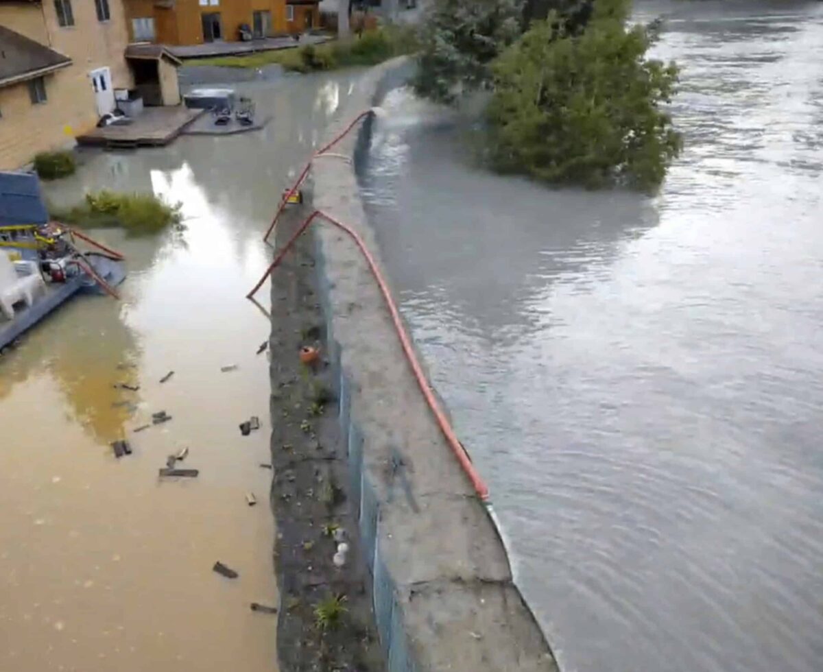
This drone image provided by the City and Borough of Juneau shows flooding from a release of water and snowmelt at Mendenhall Glacier covered some roads and threatened homes along the Mendenhall River in Juneau, Alaska on Wednesday, Aug. 13, 2025. (City and Borough of Juneau via AP)
This drone image provided by the City and Borough of Juneau shows flooding from a release of water and snowmelt at Mendenhall Glacier covered some roads and threatened homes along the Mendenhall River in Juneau, Alaska on Wednesday, Aug. 13, 2025. (City and Borough of Juneau via AP)
NOTN- Juneau officials say repairing damaged flood barriers and planning for long-term protection along the Mendenhall River will be a top priority in the wake of August’s glacier outburst flood.
At a Monday night work session, the Assembly said that Phase One of the HESCO barrier project, temporary flood walls installed to protect neighborhoods, sustained an estimated $1 million in damage.
“We are still gathering a lot of information on what happened this year, so folks are looking at, how did the basin change? How did the river change? So we still need a lot of information from our scientists before we’re ready to make any decisions.” Said Christine Woll head of the Finance Committee, “Essentially, last night, we started talking abou are we going to extend the barriers? Last year, we prioritized protecting the areas that had flooded in 2024, but as we think about the potential for this flood to increase in size, we start thinking about, do we want to extend the barriers to essentially the rest of the river? What’s the cost for that going to be and how are we going to pay for it? It starts to get kind of increasingly more expensive for the other areas of the river just because they’re trickier, and those areas are less likely to flood. So it makes for interesting policy decisions about how much the city can afford.”
The Assembly discussed whether to build barriers to a 17-foot or 18-foot model, this carries implications for construction depth, bank armoring, and overall cost. Expanding protection both north and south of the current installation could require substantial outside funding.
Members also considered long-term options for the View Drive neighborhood, where flood protection is difficult to build.
“There’s lots of challenges, but one of them is definitely View Drive, which meets the criteria of being significantly impacted every year by this flood, and yet, you know, has engineering challenges to put HESCOs up” said Woll.
Deputy City Manager Robert Barr said a potential buyout program could be pursued, but cost is the leading question.
“There’s some unanswered questions there that we need to resolve. Specifically, how much is going to cost and how many of the folks in the View Drive area need to participate for that to be a program that the federal government will participate in.” Barr said.
Last nights meeting was a Work Session however the Assembly took one actionable step, voting unanimously to shift $5 million from the Capital Civic Center project into flood mitigation. That money will help repair existing HESCO barriers and support the next phases of protection planning.
“These are decisions we’re going to have to tackle in the coming months,” he said. “We’ll keep looking for federal and state help, but ultimately we have to prepare for what may come next summer.”
The August flood, caused by an outburst from Suicide Basin above the Mendenhall Glacier, inundated neighborhoods and left behind millions in property damage.