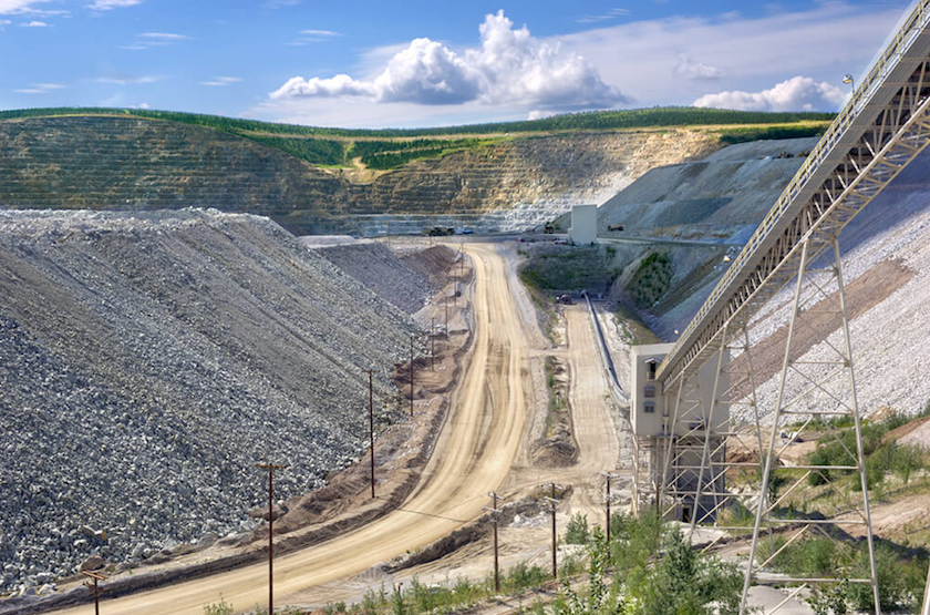
Kinross’s Fort Knox mine outside of Fairbanks in seen in this undated photo. Fort Knox produced 239,508 ounces of gold in 2024, according to the Alaska Department of Labor and Workforce Development, and it is one of the state’s six major mines. (Photo provided by Kinross Gold Corporation)
Metals mining has a prominent place in Alaska history. Today, it remains a prominent economic driver in the state.
Over the past decade, the metals mining sector has made up 3% to 4% of Alaska’s gross domestic product, and those mined metals rival Alaska seafood as top exports from the state, according to a state Department of Labor and Workforce Development analysis.
Metals such as zinc produced at the Red Dog mine in Northwest Alaska, silver produced by the Greens Creek Mine in Southeast Alaska and gold, lead and copper produced by various mines, now support an industry worth close to $3 billion a year, according to the analysis, published in the current issue of Alaska Economic Trends, the department’s monthly research magazine.
Alaska has six major metals mines, three of which produce more than one type of metal, and hundreds of small placer operations.
Among the mined products coming from Alaska is germanium, a byproduct of zinc that is classified as a critical mineral and used in electronics. In 2024, the Red Dog mine produced about 10 tons of germanium, according to the analysis, making it a critical source to the nation because China cut off deliveries of its germanium. That year, the Red Dog mine was the only U.S. mine producing germanium, though prior to 2023, a Tennessee mine was also producing the mineral, said Karinne Wiebold, the state economist who wrote the Alaska Economic Trends report.
Mining’s share of Alaska’s gross domestic product has grown considerably, as this graph shows. The graph includes values for metals mining and mining of coal, gravel and sand, but it does not include oil or gas production. Dollar figures are inflation-adjusted to 2024. (Graph provided by the Alaska Department of Labor and Workforce Development research and analysis section)
The value of Alaska’s mining sector, including coal, gravel and sand as well as metals, actually peaked in 2011 at nearly $3.5 million and close to 5% of the state’s gross domestic product. That peak reflected extremely high metals prices and the startup of the Kensington gold mine in Southeast Alaska.
Still, mining has been a strong economic factor in Alaska for the last two decades, after jumping in value in 2006. Every year since then, its total value to the state has generally been above $2 billion and usually accounted for 3% to 4% of Alaska’s gross domestic product.
Metals mining has also become a big employment driver as well, according to the analysis.
There were 3,533 metal mining and support jobs in Alaska in 2024, the most recent data available, and jobs in the sector grew by 37% over the past decade, compared to an overall state job growth rate of 0.3%, Wiebold’s analysis said.
The average metal mining job paid $135,000 in 2024, well above the state average of $71,000 that year and second only to the average pay for workers in the oil and gas sector, the analysis said.
But a large percentage of mine workers are not Alaska residents. Wiebold’s analysis puts resident hire at 56%. That puts the non-resident hire percentage in the metals mining sector well above the state average.
In 2024, the most recent year for which data is available, 22.9% of workers in the state were not Alaska residents, according to an annual report published by the Department of Labor and Workforce Development. That is the highest percentage since such records began in state average, which is the highest percentage since records started in the 1990s.
A visitor to the Donlin Gold mine site on June 23, 2025, touches core samples collected from exploration work. Donlin is one of the major Alaska projects that could be developed in the future. (Photo by Yereth Rosen/Alaska Beacon)
Wiebold noted that the nonresident hire in the mining sector is about the same as that in the oil and gas sector, which in 2024 was 40.5%, according to the state’s report.
Mining and oil and gas work in Alaska is conducive to nonresident employees because it is generally conducted at remote locations, typically with rotating schedules of two weeks on and two weeks off, she said.
“This combo means most folks don’t live near the mine and have to commute and stay at the worksite, and that there is not a significant time/cost/commute savings for living in the state,” she said by email. “As a result, miners from out of state can work in Alaska and live somewhere less expensive or more appealing to them.”
Another reason for the high percentage of nonresidents lies in Alaska’s demographics, she said. “In the last several years, with Alaska’s working age population fairly stagnant after a decade of significant declines, more jobs are being held by out of state workers,” she said.
The sector is poised for future growth, with projects like the Donlin gold mine in Southwestern Alaska, the Graphite One graphite mine in Northwestern Alaska and, potentially, the commercialization of the copper-rich but isolated Ambler Mining District in Northwestern Alaska.
But none of those proposed mines can be expected to be developed quickly, and development itself is uncertain, Wiebold’s article said.
“Mines take years to come to fruition — exploration, feasibility studies, environmental reviews, and permitting are expensive, and all have the potential to derail a project. Public concerns and controversy can also slow or stop development,” the article said.
Karmen Monigold, a member of Protect the Kobuk, a Northwest Arctic advocacy group opposed to the Ambler Access Road, poses for a portrait in Kotzebue, Alaska, Saturday, Oct. 4, 2025. (AP Photo/Annika Hammerschlag)
AP- Ice blocks drift past Tristen Pattee’s boat as he scans the banks of Northwest Alaska’s Kobuk River for caribou. His great uncle Ernest steadies a rifle on his lap. It’s the last day of September, and by every measure of history and memory, thousands should have crossed by now. But the tundra is empty, save for the mountains looming on the horizon — the Gates of the Arctic National Park.
Days after Pattee’s unsuccessful hunt, the Trump administration approved construction of the Ambler Access Road — a 211-mile (340-kilometer) route designed to reach massive copper deposits that would cut through that wilderness, crossing 11 major rivers and thousands of streams where salmon spawn and caribou migrate. The approval, which is facing lawsuits though proponents believe construction could start next year, came as record rainfall in Northwest Alaska flooded villages and ripped through fish spawning habitat — the latest climate-driven blow to Indigenous communities already watching caribou and salmon numbers plummet.
As the co-owner of a wilderness guiding company in Ambler, Pattee’s livelihood depends on keeping this landscape intact. An Inupiaq hunter, his ability to feed his family and continue the subsistence traditions of his ancestors depends on healthy caribou and fish populations.
Yet he supports building the road.
“Everything takes money nowadays,” said Pattee, who serves on Northwest Arctic Subsistence Regional Advisory Council, a federal advisory group. Jobs in local villages are scarce, and with gasoline at $17.50 a gallon, the ability to power all-terrain vehicles and boats needed to hunt is out of reach for many. Pattee estimates a single caribou hunting trip from Ambler costs $400. Mining jobs, he believes, would offer a lifeline, and the minerals could slow the climate shifts that are threatening his subsistence way of life.
It’s the irony of climate change in Northwest Alaska: the minerals needed to power the green energy transition sit beneath some of the continent’s last pristine wilderness — a landscape already on the frontlines of the climate crisis, where temperatures are rising four times faster than the rest of the planet.
“I see the climate changing. I’ve been seeing it for years now. It’s scary,” said Pattee. “Losing our culture, our tradition, is very concerning. So let’s do anything we can to help mitigate it.”
The decline before the road
Over the last two decades, the Western Arctic Caribou Herd has plummeted from nearly half a million to some 164,000 — a 66% decline, according to the Alaska Department of Fish and Game. Of those that remain, fewer now cross the Kobuk River during fall migration, where Pattee and other Inupiaq hunters would historically gather in late summer to stockpile meat for winter. While caribou populations naturally fluctuate, scientists say the increasingly delayed cold and snow that triggers the migration south has caused caribou to remain in the Brooks Range, where they are difficult for hunters to access.
The day after Pattee’s unsuccessful hunt, the first snow fell. On Oct. 6 — far later than historical norms — caribou began trickling across the Kobuk. Then the rains came, bringing heavy, late-season downpours that scientists say are becoming more common in the warming Arctic and devastating for salmon. Intense rainfall can damage and dislodge eggs, while rising water temperatures reduce oxygen levels fish need to journey upstream.
One recent study found dozens of clear streams in the Brooks Range have turned orange with toxic levels of metals — changes researchers believe is the result of permafrost thaw — which may help explain recent drops in salmon numbers. Chinook and chum salmon in particular are experiencing “sustained and dramatic declines” with periodic population crashes, which has led to complete closures of some fisheries, according to NOAA Fisheries.
Experts worry about what this year’s record storms will mean for future runs.
“Elders who’ve lived here their entire lives have never seen environmental conditions like this and they’ve never seen fish conditions this poor,” said Alex Whiting, Environmental Program Director for the Native Village of Kotzebue.
Adding pressure to a buckling landscape
The Ambler Road would add its own pressures. Thousands of culverts and nearly 50 bridges would disrupt water flow and fish passages, and more than 100 trucks would traverse the road daily over the decades-long production period. Federal biologists warn the region’s rocks contain naturally occurring asbestos and that heavy traffic would kick up dust that would settle on thousands of waterways as well as the vegetation caribou depend on. The road would also fragment the habitat of the Western Arctic Caribou Herd, potentially hindering migration patterns. The Bureau of Land Management designated some 1.2 million acres of nearby salmon spawning and caribou calving habitat as “critical environmental concern.”
Then there’s the mine. Vast amounts of water would be drawn from rivers and lakes, while groundwater levels and permafrost would be permanently disrupted. The operation would generate enormous quantities of waste rock and require a tailings facility to store toxic slurry, risking spills that could send heavy metals into waterways.
Given the record-breaking rainfall the region has seen in recent years, residents downstream worry about breaches. In Kotzebue, a hub of 3,000 at the mouth of the Kobuk where flooding prompted an emergency declaration this fall, many fear contamination could harm drinking sources and traditional Inupiaq foods like fish and bearded seals, which are already threatened by disappearing sea ice.
Poop “rolls downhill — and that’s where Kotzebue’s at,” said Karmen Monigold, an Inupiaq member of Protect the Kobuk, a grassroots effort working to stop the road, and co-chair of the Kotzebue Sound Subsistence Advisory Council.
Monigold learned to live off the land as a child from her grandparents. Determined to share her connection to nature, she taught her four sons and their cousins to hunt and fish. She’s watched climate change erode the subsistence lifestyle she fought to preserve and fears the road would accelerate that loss.
Like many opponents, she doubts promises that the road would remain private and notes other Alaska roads, such as the Dalton Highway, opened to the public despite similar assurances. An influx of outside hunters and fishers, they fear, would further stress fish and caribou populations. Even Pattee’s support for the road hinges on it being closed.
“We lose so much every generation,” Monigold said. “But right now we still have enough of a culture for it to be worth fighting for.”
In an emailed statement, Kaleb Froehlich, Managing Director of Ambler Metals, the company behind the mining project, said the operation would use proven safety controls for permafrost and will treat all water from the mining process to strict standards. The company also tracks precipitation to size facilities for heavier rainfall and has a binding agreement with NANA, an Alaska Native corporation, to prioritize recruitment from nearby communities.
Ambler Metals declined to comment on concerns specific to the road, including naturally occurring asbestos, traffic impacts, public access and habitat fragmentation, noting the company is not the road developer, though it has contributed to pre-development costs and would be its primary user. The Alaska Industrial Development and Export Authority, the state-owned investment bank developing the road, did not respond to a request for comment.
The carbon footprint of decarbonizing
Critical minerals are becoming increasingly vital — growing demand for green energy technologies could scale production by nearly 500% by 2050, according to a 2020 World Bank report. The Arctic deposit would yield not just copper, but also zinc, lead, silver and gold. At an estimated 46.7 million tons of mineral reserves, it ranks among the largest undeveloped polymetallic deposits in North America.
But there’s no guarantee the minerals would fuel clean energy. President Donald Trump has spoken openly about his disdain for electric vehicles and wind power, and the majority of copper in the U.S. goes to construction projects, according to the Copper Development Association.
The Trump administration has framed the issue as one of national security and deemed reliance on “hostile foreign powers’ mineral production” an acute threat. In March, the White House issued an executive order instructing the Secretary of the Interior to prioritize mineral production and mining as the primary land use on all federal lands known to hold mineral deposits.
Yet even that argument doesn’t quite fit. While the U.S. is heavily reliant on China for some 20 different minerals, the Arctic deposit’s primary minerals — copper and zinc — are not among them, according to the 2025 USGS report. The U.S. sources 45% of its refined copper from Chile, Canada, Mexico and Peru, and 73% of its zinc from Canada and Mexico. The rest is mined domestically.
The real issue isn’t whether the minerals are needed — it’s who gets to decide, said Andrea Marston, an associate professor of geography at Rutgers University who studies mining and Indigenous rights in the Americas. Mining projects like Ambler are sometimes located on Indigenous lands, creating what she calls a false ethical dilemma: mine to save the climate, or protect the land and perpetuate warming. That framing, she argues, obscures other possibilities like investing in mass public transportation, recycling minerals that already exist and designing systems that consume less.
“You cannot justify steamrolling Indigenous lands with a kind of global story of climate change because that just ends up reiterating colonial plunder in a new way,” she said. “The starting point should be: it is their land to decide what to do with.”
A community divided
Ambler mayor Conrad Douglas recognizes the exorbitant cost of living in his village and the desperate need for jobs. But he also knows the Canadian and Australian mining companies that hold the rights to the Ambler deposits may source workers from elsewhere, and he fears what it would all do to the land.
His concerns are layered: fugitive dust, tailings runoff and a cruel cycle where increasingly heavy rains wipe out fish runs, forcing people to rely more on caribou just as the road threatens to further disrupt those herds. With gas prices already putting hunting out of reach for many families, the equation becomes impossible.
“I don’t really know how much the state of Alaska is willing to jeopardize our way of life, but the people do need jobs,” he said, dressed in a pro Ambler Road hoodie.
Douglas worked at Red Dog Mine in the early 1990s and has seen how it benefited neighboring villages with jobs and community support. But he worries the companies behind Ambler won’t take the same approach.
For Pattee, the jobs represent more than income — they would allow people to reconnect with their culture. Young Inupiaq hunters once took immense pride in providing for their families, he said.
“That was their proud moment. That was what they lived for,” he said. “Nowadays, without being able to afford hunting, a lot of that’s been taken away.”
As for impacts on fish and caribou, Pattee believes mining safeguards work. In addition to wilderness guiding, he works as an environmental technical supervisor at Red Dog Mine and has seen good practices firsthand.
Still, “there’s always a worry,” he said.
What would be left
Nick Jans, an author who moved to Ambler in 1979, has watched the landscape transform over 46 years. When he first arrived, permafrost banks held firm against the rivers and caribou poured through by the hundreds of thousands.
The road, he argued, would deliver the final blow to a landscape already stressed by climate change.
“This isn’t about my backyard — this is about your backyard. This is the world’s backyard,” he said, his voice catching. “We have to protect something that was this planet as it was before us. Otherwise, we’re gonna lose our way. And I would say we already have.”
The night after his unsuccessful hunt, Pattee and his family gathered around a table of bowhead whale, beluga, seal and moose — a rare meal all together as relatives had flown in from Anchorage. Like many in Ambler, Pattee’s family members have left over the years to find jobs. In a village this small, each departure is felt — the population has dwindled from 320 in 2010 to some 200 today.
“We’re losing our community. We’re literally losing it,” he said. “People want to be home but they just don’t have the opportunities to keep them there.”
Third in a three-story series on mining in Alaska published in a partnership between Inside Climate News and Northern Journal. Read parts one and two.
By: Max Graham, Northern Journal
The Johnson Tract is a private parcel with a worker camp and airstrip, surrounded by the vast Lake Clark National Park. (Photo by Max Graham/Northern Journal)
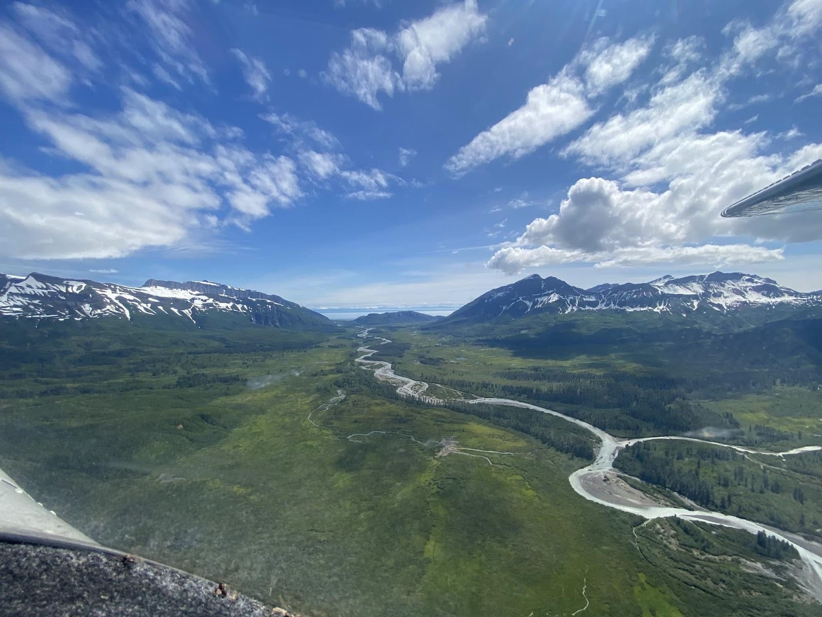
COOK INLET, Alaska—High in a mountain valley on the far west side of this tidal inlet sits an unusual plot of land.
It’s a private parcel, with a gravel airstrip and four or five buildings that make up a small worker camp. But there are no towns in sight. Known as the Johnson Tract, the property is fully surrounded by the vast Lake Clark National Park—millions of wild acres marked by the broad white peaks of a volcano, sprawling glaciers and a muddy ocean coastline patrolled by brown bears.
Beneath the Johnson Tract lies a potential fortune. For decades, geologists have eyed gold, copper and zinc deposits thought to be worth billions of dollars. But they’ve never been tapped.
Now, amid surging gold prices and rising demand for metals like copper, the prospect is generating new excitement—and concern.
A prominent Alaska mining company is leasing the Johnson Tract from its Indigenous owners, and the property, some 125 miles southwest of Anchorage, has emerged as one of the most promising mining prospects in Southcentral Alaska.
But conservationists, commercial salmon fishermen and local lodge owners fear a mine, encircled by the federal protected area, could disrupt harvests and harm wildlife, including an endangered population of beluga whales.
Getting the Johnson Tract’s minerals to buyers will require trucking ore through a now-roadless corner of the national park to a future port.
Critics point out that the bay where the mining company, Contango Ore, Inc., wants to build a shipping terminal is an important winter habitat for the endangered belugas. Concern for the whales, among other objections, led mine opponents to sue federal regulators earlier this year over a permit that Contango received to build a short access road and expand an airstrip at the site.
Mount Iliamna, a volcano in Lake Clark National Park, rises above Tuxedni Bay and a commercial fish camp on Chisik Island. (Photo by Max Graham/Northern Journal)
Still, the project is advancing.
The land is owned by Anchorage-based Cook Inlet Region, Inc., or CIRI, one of 12 Indigenous-owned regional corporations created by Congress as part of a wider land claims settlement with Alaska’s Native people in 1971.
Contango, based in Fairbanks, started leasing the land from CIRI last year. With gold prices surpassing a record high of $4,000 per troy ounce this year, the mining company is already planning new roads and a tunnel to allow underground drilling on the Johnson Tract.
If a mine gets built, both Contango and CIRI’s nearly 10,000 Indigenous shareholders are poised to profit.
“The stars might be aligned right now,” said Margie Brown, a former CIRI president who also worked for the corporation’s lands department in the 1970s, when the company acquired the prospect.
The conflict reflects a deeper tension between two competing visions for Alaska—one of environmental preservation, the other of industrial development. Both visions extend back to a time when Congress set aside large tracts of the state’s wilderness for protection but also carved out areas for resource extraction, often intended to benefit Alaska’s Indigenous-owned corporations. Rooted in a series of landmark bills in the 1970s and 1980s, the Johnson Tract saga echoes some of the state’s other, higher-profile environmental battles, including over a mining road and oil development in the Arctic.
As Contango forges ahead, CIRI is asserting its right to profit from lands long intended for development, while opponents say that mining imperils a still-wild slice of Alaska.
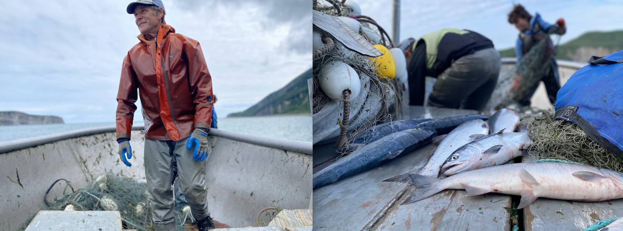
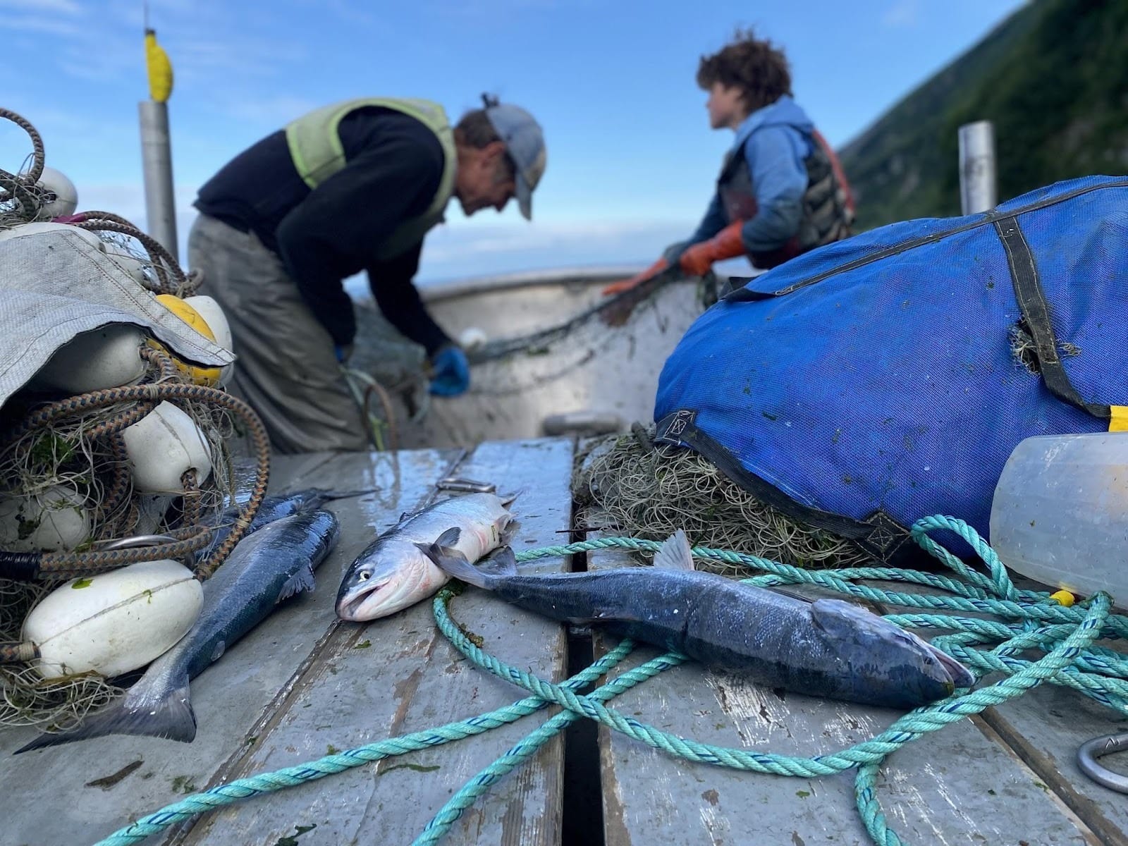
Commercial fisherman Dustin Solberg, left, walks across the bow of his skiff at the mouth of Tuxedni Bay. Solberg fishes with his son, Leif. (Photos by Max Graham/Northern Journal)
Among critics of the mining project is Dustin Solberg, a commercial fisherman and environmental advocate who spends summers with his family setting nets for salmon along the beaches of Tuxedni Bay, about 10 miles northeast of the Johnson Tract. Contango could one day load ore onto ships from the same shore where Solberg and other fishermen haul fish out of the bay.
Standing on a quiet Tuxedni beach one day this summer with dramatic cliffs looming overhead, Solberg imagined mining trucks rumbling down a road nearby.
“I think it would irreversibly change this place,” he said.
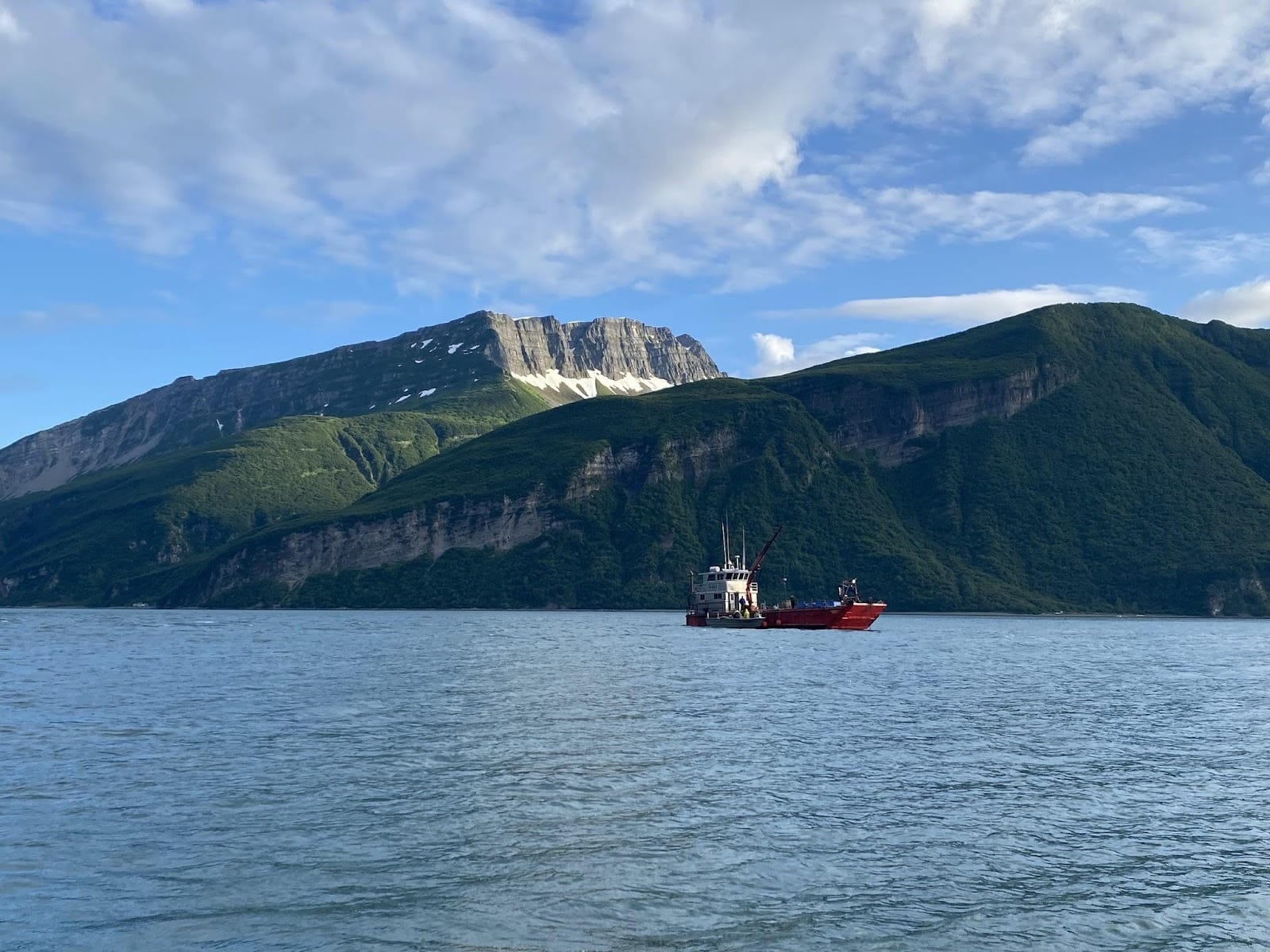
A fishing tender anchored in Tuxedni Channel, with Lake Clark National Park in the background. The tender buys salmon from the bay’s fishermen and transports it across the inlet to a processing plant in the town of Kenai. (Photo by Max Graham/Northern Journal)
A pivotal deal
The Johnson Tract fight is rooted in the Alaska Native Claims Settlement Act.
Intended to resolve disputes over Indigenous land claims in Alaska, the federal legislation in 1971 established 12 for-profit Alaska Native corporations, each owned by Indigenous shareholders with ties to a region in the state. More than 200 other Indigenous companies tied to Native villages also formed.
The act promised to compensate the corporations with nearly a billion dollars and millions of acres of land, to be chosen by the companies’ elected leaders.
Those leaders quickly moved to obtain traditional hunting and fishing grounds and areas with cultural value, but they also sought land thought to be rich in minerals and other resources that they could convert into profits for shareholders.
In the Arctic, Native corporations acquired land with oil deposits. In Southeast Alaska, they logged vast stands of cedar and spruce.
But in CIRI’s region, around Anchorage and neighboring Cook Inlet, the pickings were sparse. The southcentral region is the state’s most populous, and by the time of the settlement, military bases and wildlife refuges had been set aside by the federal government, prime real estate was in the hands of private developers and other parcels had been snatched up by the state.
“You just had so much pressure for lands within the Cook Inlet region,” said Brown, who now serves on CIRI’s board.
The corporation’s leaders argued that they were largely left with glaciers and mountain ridges — dim prospects for shareholders.
CIRI’s headquarters in Midtown Anchorage. (Photo by Max Graham/Northern Journal)
Two years after Congress approved the settlement, CIRI sued the U.S. interior secretary, arguing that his agency had not made adequate property available for CIRI to develop. Tense negotiations ensued, producing a sprawling agreement between CIRI and the state and federal governments: the Cook Inlet Land Exchange.
The deal called for CIRI to give up half the property around Cook Inlet that the corporation was entitled to under the original settlement, Brown said. Some of that foregone land would be folded into Lake Clark National Park and Preserve when Congress created it a few years later.
In return, CIRI would be able to acquire land elsewhere in Alaska, and even outside the state.
The Johnson River flows about a dozen miles from the Johnson Tract through Lake Clark National Park into Cook Inlet. (Photo by Max Graham/Northern Journal)
The deal also allowed CIRI to pick up some key assets around Cook Inlet, including the Johnson Tract, which the corporation chose specifically for its mineral potential. CIRI’s early leaders viewed the land swap as a hard-fought compromise, and Brown called the Johnson Tract “key to the bargain.”
“The ability to use the land in the way Congress intended is something that needs to be preserved,” she said. “It’s unfortunate that as we move further and further from congressional intent, it’s harder and harder for people to remember that.”
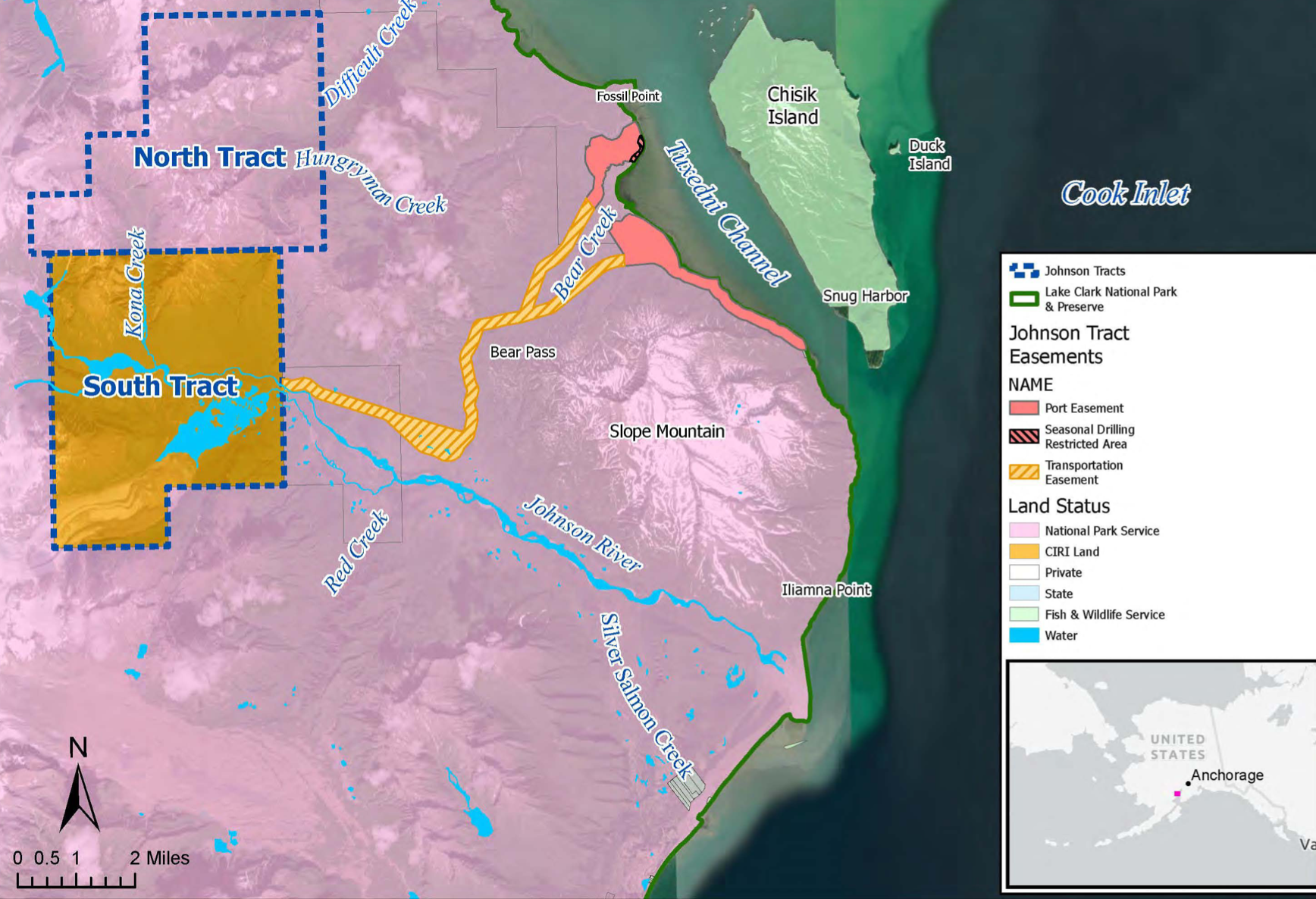
The Johnson Tract is really two adjacent parcels, totaling about 33 square miles. CIRI—now a huge business, with nearly $1 billion in assets—owns the minerals beneath both parcels, and the surface of the south tract, where the main deposit sits. The federal government retained surface ownership of the north tract.
Citing a provision in the land exchange, the Department of Interior earlier this year granted CIRI the rights to transport ore through the park, with certain restrictions to limit environmental impacts. CIRI and Contango have not formally proposed building a haul road and port, which would require additional permits.
An “Awesome” Deposit
Soon after CIRI acquired the Johnson Tract, the corporation began scouring it for more minerals, seeking enough to justify building a mine.
In the early 1980s, CIRI partnered with Anaconda Minerals, a subsidiary of the global oil giant ARCO, to evaluate the prospect.
Anaconda found promising amounts of gold, zinc and copper and at one point—given the area’s prolific amount of snow—envisioned an underground tunnel or aerial tram to move ore the dozen miles from a mine to a port on the coast. But Anaconda went out of business. And aside from another unsuccessful effort to develop the Johnson Tract in the 1990s, the land sat largely dormant until 2019.
That year, CIRI signed a lease with a Vancouver-based mineral exploration company, which quickly handed over the operations to a spinoff firm, HighGold Mining Inc. HighGold spent tens of millions of dollars on exploration and drilled more than 150 core samples before Contango bought the company last year in a deal worth some $35 million.
The Johnson Tract appealed to Contango’s chief executive, Rick Van Nieuwenhuyse, because it seemed to be a good fit for the company’s unconventional development model, which involves shipping raw ore to a processing plant off site, rather than crushing and processing ore next to the deposit, as most mines do.
The approach avoids some of the more expensive and hard-to-permit components of a typical mine, like a mill and a big waste pond. In theory, it keeps construction costs low and makes permitting easier, Van Nieuwenhuyse said. But shipping unprocessed ore also risks higher transportation costs, so Johnson Tract’s close proximity to the ocean and shipping routes made it attractive.
“It’s an awesome deposit,” Van Nieuwenhuyse said, citing the prospect’s high ratio of valuable minerals to rock and its thickness, which he expects will make the mining process more efficient.
Van Nieuwenhuyse is a veteran of Alaska’s mining industry, having worked over the past four decades on some of the state’s most prominent early-stage projects.
He played major roles in advancing Western Alaska’s Donlin project — the state’s biggest proposed gold mine — and high-profile prospects in Northwest Alaska at the end of the controversial proposed Ambler Road. He also led development of the Rock Creek gold mine near Nome, which closed in 2008 soon after opening amid a slew of challenges.
At Contango, where Van Nieuwenhuyse was named chief executive in 2020, he partnered with the multinational Kinross Gold Corp. to spearhead the construction of Alaska’s first large mine in more than a decade, a project in the Interior called Manh Choh.
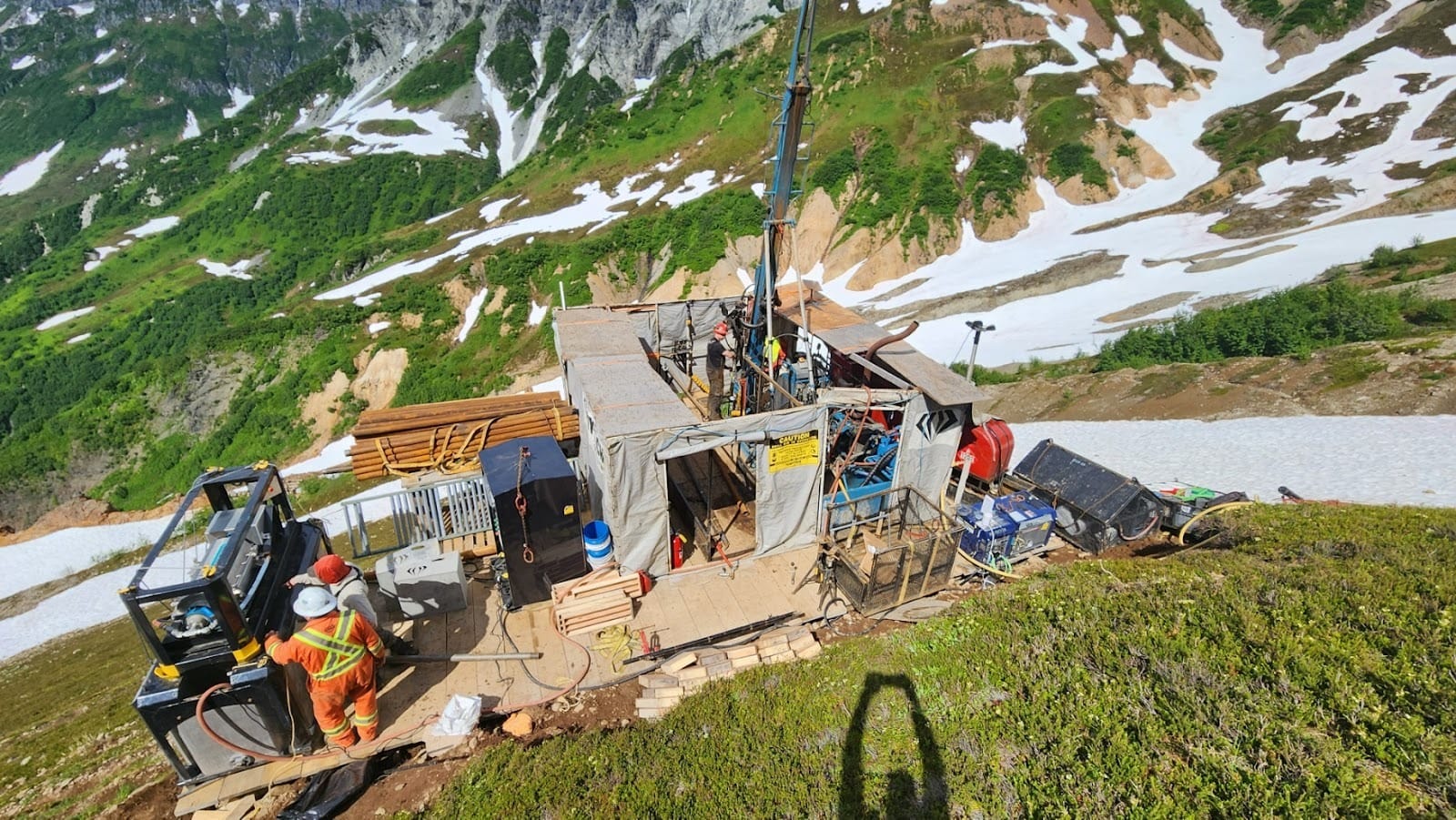
Unlike that open-pit mine, Johnson Tract would be an underground operation. Several years of exploratory drilling, permitting and engineering are expected before a final decision on building a mine, Van Nieuwenhuyse said.
A drilling pad at the Johnson Tract project. (Photo from Contango Ore)
The mine, according to Contango’s preliminary plans, would operate for seven years and would be small compared to other major Alaska mines. Contango would share royalties on mineral sales with CIRI, which has an option to buy as much as a 25 percent stake in the mine.
CIRI declined interview requests about the Johnson Tract, and the corporation’s executives have made few public statements about it.
The project “presents an opportunity to responsibly develop mineral resources to benefit our shareholders while respecting the environment and preserving the land,” CIRI said in a brief update last year. “The Johnson Tract project reflects decades of hard work to build a foundation of self-determination and financial stability.”
“We’re Here Because it’s Beautiful”
Dustin Solberg, the fisherman and mine opponent, was motoring to a net he’d set on the west side of Tuxedni Channel one afternoon last summer when he spotted a brown bear on a rocky beach ahead.
“I think it smells the fish, Dad,” 12-year-old son and deckhand Leif Solberg called out.
Far more worrisome to the elder Solberg is the future of the beach where the bear was roving—near a site that Contango is studying as a port.
Solberg, his family and others who fish in the channel each summer have growing concerns about Contango’s vision. They fear that a new road and industrial dock, and the traffic and noise from trucks and ships, would mar the wild character of the bay and the park around it.
Dustin and Leif Solberg haul salmon out of Tuxedni Channel. (Photo by Max Graham/Northern Journal)
As Solberg looked across the channel, it was remarkably quiet, aside from a few fishing skiffs and an occasional float plane that landed at a bear-viewing lodge on Chisik Island. Other than the lodge and a few fishing cabins, Chisik is a federally designated wilderness area, home to a prolific seabird colony.
A dozen or so crews fish commercially for salmon in the bay. Two or three times a week, from June through August, they set, pick and pull nets along pebbly beaches on either side of Tuxedni Channel, with fishing periods that can last 12 hours or more.
It’s hard labor, Solberg said, but the season moves at a slower pace than Alaska’s bigger-volume salmon fisheries, like Bristol Bay, where boats sometimes work 24-hour shifts.
Dustin and Leif Solberg work their net behind freshly caught salmon in Tuxedni Channel. (Photo by Max Graham/Northern Journal)
“If you wanted to make money, you would fish somewhere else,” said Ann Harding, Solberg’s wife. “We’re here because it’s beautiful.”
The area has “phenomenal” mountains and a striking density of birds and bears, added Harding, a seabird biologist who sometimes fishes alongside Solberg.
Ann Harding handles a freshly caught salmon as Dustin Solberg pulls another out of his net. (Max Graham/Northern Journal)
The family uses a cabin a mile or two down the shoreline from where the bear had been walking. It’s a small plywood structure beneath an A-frame roof, surrounded by an electric fence to keep away curious ursine visitors. The cabin is about a hundred feet back from the water and set fully within Lake Clark National Park.
Solberg and Harding bought the structure several years ago. They don’t have title to the land beneath it or a formal permit from the park service. But the cabin existed before the park was established, and past owners had an informal arrangement with federal officials to keep using it, Solberg said.
A cabin used by fisherman Dustin Solberg and his family stands in Lake Clark National Park, near the shore of Tuxedni Channel. (Photo by Max Graham/Northern Journal)
The cabin now sits in an easement that the Department of Interior earlier this year granted CIRI for a mining port. Solberg doesn’t think his small business will amount to much of an obstacle.
“This is just a little shack that doesn’t really compete with the value of an operation like that,” he said, referring to the mining plans. “So, I don’t expect this to get in the way of anything.”
A National Park Service Map of the Johnson Tract, as well as easements where an access road and port serving a mine could one day be built.
CIRI and Contango have not made a final decision about where to put the port, and a CIRI environmental document said last year that there is “considerable uncertainty” about future construction.
Van Nieuwenhuyse, the Contango mining executive, said his company recognizes the rights of the setnetters, and he believes a mine can co-exist with the fishery.
“I would ask that everybody recognize CIRI’s rights as well,” he added.
Where Belugas “Hang Out”
As it gathers pace, Contango is facing opposition not just from the commercial fishermen but also from conservation groups and some tribal governments in the region.
A national group, the Center for Biological Diversity, along with the Homer-based nonprofit Cook Inletkeeper and the Chickaloon Village Traditional Council, a tribal government, are suing the U.S. Army Corps of Engineers for issuing a key permit to Contango.
Several tribal leaders also have raised concerns about the project and have asked the Trump administration to suspend the permit.
A core concern among those opponents is that a mining operation could threaten Cook Inlet’s beluga whales, which are treasured by many Anchorage residents and local wildlife viewers.
The inlet’s belugas—which are genetically distinct from other beluga populations—once numbered around 1,300 animals, but their numbers sharply declined in the 1990s. They were listed as endangered in 2008 and still have not significantly recovered. The population now stands at some 330 whales.
Tuxedni Bay, ringed by the mountains of Lake Clark National Park, is an important winter habitat for an endangered population of beluga whales, according to recent federal research. (Photo by Max Graham/Northern Journal)
During the summer, the belugas are commonly spotted feasting on fish at the mouths of salmon-bearing streams near Anchorage. Where they go in winter has been a mystery.
But last year federal scientists announced a big discovery in a study that analyzed underwater sound recordings.
The researchers, affiliated with the National Oceanic and Atmospheric Administration, identified Tuxedni Bay as the only known foraging ground for the whales between late fall and late spring. They warned that human-caused noise is a “key threat” to the belugas, which use sound to navigate and communicate, and that industrial activity could affect the quality of the whales’ habitat.
NOAA Fisheries, which led the study, declined interview requests. One of its scientists, in a press release announcing the study, said that “maintaining the status quo” may be all that’s needed to help the beluga population recover.
As Contango studies sites for a port, it’s now funding a new beluga survey by biologists working for the state of Alaska, which has often been more friendly to the mining industry than the federal government.
The survey is focused on the narrow channel where Contango is considering shipping ore, while the NOAA-led study looked more broadly at the 10-mile-long Tuxedni Bay.
“We want to know where the belugas like to hang out,” Van Nieuwenhuyse said.
One of the loudest voices advocating for the belugas and against development at the Johnston Tract is Cooper Freeman, a Homer resident and the Alaska director at the Center for Biological Diversity. The center is a 35-year-old nonprofit that aims to protect wildlife and ecosystems across the country, and it’s a participant in nearly a dozen active lawsuits in Alaska’s federal court.
In an interview, Freeman acknowledged CIRI’s right to the minerals at the Johnson Tract. But he noted that federal environmental laws still apply and argued that CIRI does not have an “absolute right” to build a mine.
In his view, the area is too ecologically rich—with its important beluga habitat and high density of brown bears, seabirds and shorebirds—to risk.
“It’s just an incredibly, biologically, intensively rich and completely intact area—one of the only remaining places like it in all of Cook Inlet,” he said. “I don’t think there’s any amount of money that’s worth destroying this place.”
Chisik Island is a federally designated wilderness area, aside from a few commercial fish camps and a bear-viewing lodge. (Photo by Max Graham/Northern Journal)
There are no towns within 40 miles of the Johnson Tract—just roadless mountains, glaciers, forests and streams.
Aside from seasonal fishermen, CIRI and Contango’s neighbors include Silver Salmon Creek Lodge, a bear-viewing and sport-fishing business that’s near the mouth of the Johnson River, a dozen or so miles downstream of the mineral deposit.
Longtime lodge owners David Coray and Joanne Edney have kept loose tabs on the prospect for decades and have grown more concerned as Contango’s project advances.
In a recent interview, Coray and Edney said they’re worried that a mine could pollute the Johnson River and disrupt bear habitat.
“We understand their interest, and we understand their rights,” Edney said of CIRI and Contango. But a mining operation could come into “direct conflict” with her family’s business, she said.
CIRI declined to respond to questions about opposition to the project, and about how it’s gauging the views of its shareholders, some of whom have spoken out against it.
Van Nieuwenhuyse said Contango is committed to protecting wildlife.
“We’ll develop this deposit with minimal impacts to the environment, which we recognize as pristine,” Van Nieuwenhuyse said. “We’re all from Alaska. We enjoy the outdoors. That’s why we all became geologists.”
For Solberg, the fisherman, the convergence of competing interests in the area is “endlessly fascinating—and really complicated and really unfortunate.”
In a conversation after the fishing season, Solberg acknowledged a tension between CIRI’s rights to the Johnson Tract’s minerals and the spectre of a mine transforming the landscape and bay that his family has come to know and love.
Solberg said he feels “really torn” about the issue and that he respects CIRI’s land claims. But as one of the few Alaskans who spends long stretches of time in Tuxedni Bay, he feels obligated to speak in defense of its wildness and beauty.
“I just want decisionmakers to have their eyes wide open,” he said. “And to realize what’s at stake.”
This story was supported by a grant from the Alaska Center for Excellence in Journalism.
Northern Journal contributor Max Graham can be reached at max@northernjournal.com. He’s interested in any and all mining related stories, as well as introductory meetings with people in and around the industry.
This article was originally published in Northern Journal, a newsletter from Nathaniel Herz. Subscribe at this link.
Along the trans-Alaska oil pipeline, pictured here, runs a smaller-diameter natural gas line used to fuel the oil pipeline’s pumps. That small-diameter line could be a source of fuel for a new Bitcoin mining operation on the North Slope. (Arthur T. LaBar/Flickr under Creative Commons License)
Despite the federal government shutdown, the Trump administration is proceeding with new oil leasing on Alaska’s North Slope.
The U.S. Bureau of Land management said Tuesday it will be accepting nominations for areas to auction in an upcoming oil and gas lease sale in the National Petroleum Reserve in Alaska. The call for nominations is the first step in the leasing process; comments on suggested leasing areas will be taken for 30 days, the BLM said.
The information is in a Federal Register notice scheduled to be published on Wednesday.
The pending lease sale is in accordance with the sweeping budget bill, signed by President Donald Trump on July 5, that he and his supporters call “The One Big Beautiful Bill.” The bill requires the BLM to hold at least five lease sales, each offering at least 4 million acres, over the next 10 years.
“Congress directed a program of expeditious leasing and development in the NPR-A to support America’s energy independence, and that is more important today than ever,” Kevin Pendergast, Alaska state director for the BLM, said in a statement. “This lease sale gets us back on track toward further exploration and development in the reserve, as Congress envisioned.”
The upcoming lease sale is intended to be under new Trump-era rules that remove protections enacted by the Biden administration, the Obama administration and earlier administrations, dating back to former President Ronald Reagan’s term.
A female caribou runs near Teshekpuk Lake in the National Petroleum Reserve in Alaska on June 12, 2022. The Teshekpuk caribou herd gives birth to its calves in the land around the vast lake, the largest on the North Slope. Under the Trump administration, long-protected areas and around the lake will be opened to oil development. (Photo by Ashley Sabatino/ U.S. Bureau of Land Management)
Under the Trump rules, more than 18.5 million of the reserve’s 23 million acres are designated as available for leasing. That includes the ecologically sensitive Teshekpuk Lake, the largest lake on the North Slope, which is important habitat for migratory birds and which is adjacent to the calving grounds for the Teshekpuk caribou herd.
Lease sales in the reserve were held about every two years from 1999 to 2010 and annually from 2011 through 2019, but with protections for certain areas, including Teshekpuk Lake.
The Obama administration had a policy of coordinating those federal auctions with the annual areawide North Slope, Beaufort Sea and Brooks Range Foothills sales held by the Alaska Division of Oil and Gas. Coordinated timing on those enhanced industry interest and convenience, agency officials said at the time.
No lease sales have been held since the 2019 auction held under the first Trump administration. After that, that administration shifted its focus to the Arctic National Wildlife Refuge. Two lease sales were held in the refuge, in January 2021 and January 2025. The first of those sales drew few bids, none of them from major oil companies, and the 2025 sale drew no bids.
Environmentalists criticized the move toward a sale during a government shutdown.
“The Trump administration’s outrageous announcement shows a sad truth in our country today: The government is open for resource extraction corporations and closed for the people,” Andy Moderow, senior director of policy at Alaska Wilderness League, said in a statement. “At a time when our government is shut down and essential public workers aren’t getting paid, it’s outrageous that federal leaders are prioritizing oil and gas sales over getting the country back on its feet.”
Red-necked phalaropes forage in the wetlands found in the northeastern section of the National Petroleum Reserve in Alaska. Teshekpuk Lake and the wetlands around it comprise one of the top habitats for migratory birds anywhere in the Arctic. The Trump administration has opened those wetlands to oil development; they had been off-limits for decades. (Photo by Bob Wick/U.S. Bureau of Land Management)
Cooper Freeman, Alaska director at the Center for Biological Diversity, echoed that sentiment in a different statement.
“The Trump government clearly isn’t shut down for the oil industry, with millions upon millions of Alaska’s western Arctic recklessly open for exploitation and desecration,” he said.“We can’t let this administration destroy key habitat for cherished wildlife like caribou, polar bears and millions of migratory birds for nothing more than stuffing oil barons’ pockets.”
A Department of the Interior spokesperson said certain BLM employees remain on duty to handle energy issues, a subject that Trump has said needs emergency action.
“Activities necessary to address the President’s declaration of a national energy emergency are continuing during the lapse in appropriations. The Bureau of Land Management has staff working in both exempt and excepted status to carry out essential energy-related responsibilities, including review of nominations for the National Petroleum Reserve–Alaska lease sale,” said Alice Sharpe, senior public affairs specialist with the department, in an email.
Unlike the Arctic refuge, which is on the eastern side of the North Slope, the National Petroleum Reserve on the western side of the North Slope has drawn industry interest. The reserve is underlain by an oil-rich formation called Nanushuk that has yielded significant discoveries on both federal and state land.
Some of those discoveries have resulted in producing oil fields, and more are expected. ConocoPhillips’ huge Willow project, which the company has said will produce up to 180,000 barrels a day from reserves totaling about 600 million barrels, is located in the reserve and is set to become the North Slope’s westernmost producing oil field.
The Gates of the Arctic National Park and Preserve, where the Ambler Road project would pass through, is visible from Ambler, Alaska, Sunday, Sept. 28, 2025. (AP Photo/Annika Hammerschlag)
Senators voted 50-46 Thursday to repeal a land management plan for a large swath of Alaska that was adopted in the final weeks of Democratic President Joe Biden’s administration. Lawmakers voted to roll back similar plans for land in Montana and North Dakota earlier this week.
The timing of Biden’s actions made the plans vulnerable to the Congressional Review Act, which allows Congress to terminate rules that are finalized near the end of a president’s term. The resolutions require a simple majority in each chamber and take effect upon the president’s signature.
Trump ordered approval of the Ambler Road project earlier this week, saying it will unlock access to copper, cobalt and other critical minerals that the United States needs to compete with China on artificial intelligence and other resource development. Copper is used in the production of cars, electronics and even renewable energy technologies such as wind turbines.
The road was approved in Trump’s first term, but was later blocked by Biden after an analysis determined the project would threaten caribou and other wildlife and harm Alaska Native tribes that rely on hunting and fishing.
The Biden-era restrictions also included a block on new mining leases in the nation’s most productive coal-producing region, the Powder River Basin in Montana and Wyoming. On Monday, the Trump administration held the biggest coal sale in that area in more than a decade, drawing a single bid of $186,000 for 167.5 million tons of coal, or about a tenth of a penny per ton.
Trump has largely cast aside Biden’s goal to reduce climate-warming emissions from the burning of coal and other fossil fuels extracted from federal land. Instead, he and congressional Republicans have moved to open more taxpayer-owned land to fossil fuel development, hoping to create more jobs and revenue. The Republican administration also has pushed to develop critical minerals, including copper, cobalt, gold and zinc.
A decision on whether to accept the recent bid from the Navajo Transitional Energy Co. is pending, and the lease cannot be issued until the Montana land plan is altered. The dirt-cheap value reflects dampened industry interest in coal despite Trump’s efforts. Many utilities have switched to cheaper natural gas or renewables such as wind and solar power.
Administration officials expressed disappointment that they did not receive “stronger participation” in the Montana sale. In a statement, Interior Department spokesperson Aubrie Spady blamed a “decades long war on coal” by Biden and former Democratic President Barack Obama.
Republican Sen. Tim Sheehy of Montana said the repeal of the land-management plan in his state was “putting an end to disastrous Biden-era regulations that put our resource economy on life support.”
Republican Sen. Dan Sullivan of Alaska called the Biden-era plan for 13 million acres in the central Yukon region “a clear case of federal overreach that locks up Alaska’s lands, ignores Alaska Native voices … and blocks access to critical energy, gravel & mineral resources.”
The GOP legislation “restores balance, strengthens U.S. energy & mineral security and upholds the law,” Sullivan said in a statement.
Democrats urged rejection of the repeals, arguing that Trump’s fossil fuel-friendly agenda is driving up energy prices because renewable sources are being sidelined even as the tech industry’s power demands soar for data centers and other projects.
“We are seeing dramatic increases in the price of energy for American consumers and businesses and the slashing of American jobs, so that Donald Trump can give an easy pass to the fossil fuel industry,” Democratic Sen. Tim Kaine of Virginia said Wednesday on the Senate floor.
Last week, the administration canceled almost $8 billion in grants for clean energy projects in 16 states that Democratic presidential candidate Kamala Harris won in the 2024 election.
Ashley Nunes, public lands specialist at the Center for Biological Diversity, an environmental group, said Republicans were unleashing “a wholesale assault on America’s public lands.” Using the Congressional Review Act to erase land management plans “will sow chaos across the country and turn our most cherished places into playgrounds for coal barons and industry polluters,” she said.
In this screenshot from a White House news conference, Interior Secretary Doug Burgum points to a map of Alaska on Monday, Oct. 6, 2025, as he announces the Trump administration’s decision to reverse a Biden administration action that canceled a right-of-way permit for the Ambler Road. (Screenshot)
The action removes a major hurdle for the project, but developers would still need to overcome lawsuits and opposition from environmental and tribal groups. They would also need approval from NANA and Doyon Ltd., two Alaska Native regional corporations who own land in the road’s path.
Ambler Road, planned by the state of Alaska’s development bank and supported by state officials and Alaska’s congressional delegation, would link the Dalton Highway with a mineral-rich region of northwest Alaska, providing access to the mining of rare minerals needed for batteries and high-technology manufacturing.
“It’s an economic gold mine, so to speak. I signed this years ago, and Biden un-signed it for me,” Trump told reporters on Monday at the White House.
Last year, the U.S. Bureau of Land Management concluded that the road would have a litany of negative impacts, and the Biden administration issued a record of decision saying that the best route for the project was no route at all.
The Alaska Industrial Development and Export Authority, Alaska’s state-owned investment bank and the road’s developer, sued the Biden administration, seeking a reversal.
U.S. Interior Secretary Doug Burgum, speaking at the White House on Monday, said the state of Alaska requested an appeal of that decision, and that under federal law, President Trump has the executive authority to make decisions on land use.
The appeal in question was filed by AIDEA under Section 1106 of the Alaska National Interest Lands Conservation Act of 1980.
“This opens up a wealth of resources,” Burgum said, adding that the federal government will also take partial ownership of Trilogy Metals, one of several firms exploring for minerals in northwest Alaska.
As currently planned, the road would consist of a gravel strip stretching from the Dalton Highway almost to Kotzebue. It is envisioned as a toll road, with no public access, and the cost of construction would be paid for via fees levied on users, similar to the way the AIDEA-funded DeLong Mountain Transportation System provides a port for lead and zinc exported from the Red Dog Mine in northwest Alaska.
In a special late-September meeting, AIDEA’s board voted to authorize limited negotiations with landowners in the road’s path.
The road is expected to cross more than 10 miles of land owned by Doyon Ltd., the regional Alaska Native corporation for Interior Alaska.
To date, that corporation hasn’t expressed official support or opposition for the road. Sarah Obed, senior vice president of external affairs for Doyon, said by email that Monday’s announcement was “not a surprise to Doyon” because of a different executive order signed earlier this year.
NANA Regional Corp. owns more than 20 miles of land in the path of the road. In a written statement, NANA President and CEO John Lincoln said the company “appreciates the Trump Administration and Governor Dunleavy’s support for economic development in Alaska and their work towards stabilizing the federal permitting process” but he declined to express support for the road.
Lincoln said that still stands: “Our position on the Ambler Access Project has not changed and will only be reconsidered if and when our established criteria are satisfied, in consultation with shareholders, local communities, and other stakeholders.”
Trump’s action on Monday restores a federal right-of-way grant issued in 2021, at the end of the first Trump administration. It also requires federal agencies to issue clean-water permits and other approvals needed for the road.
A lawsuit challenging the 2021 right-of-way grant remains open in the U.S. District Court in Anchorage. Attorney Bridget Psarianos, with the nonprofit law firm Trustees for Alaska, is one of the attorneys challenging that right-of-way.
By phone, she said she hasn’t ever seen a president use the authority that Trump did on Monday.
“He’s wielding this presidential power like a cudgel, including to overturn decisions that his own agencies have made and provided good reasons for,” she said.
The Tanana Chiefs Conference, a group of 39 Interior villages and 37 federally recognized tribes, opposes the road. In a statement Monday, it said it was “deeply disappointed by the decision.”
“This decision is a direct affront to the voices of Alaska Native people,” said Chief/Chairman Brian Ridley in a written statement. He added that TCC will continue to fight the project.
Psarianos, by phone, said that the BLM opposed the project in 2024 “because they found that there would be significant impacts to subsistence and to communities and their health along the road corridor.”
Athan Manuel, director of the environmental nonprofit Sierra Club’s Lands Protection Program, offered similar thoughts in a written statement. “This order ignores those voices in favor of corporate polluters. The Ambler Road will lead to significant harm to fragile Alaskan landscapes and the local communities and wildlife that rely on them,” he said.
Most of the road’s path is on land owned or controlled by the state of Alaska; an easement allowing the road remains under consideration by the Alaska Department of Natural Resources, but approval is expected.
In a statement published after Trump’s announcement on Monday, Gov. Mike Dunleavy thanked the president for his action, saying, “this decision will unleash development opportunities, create new jobs for Alaskans and secure access to strategic minerals.”
Similarly, all three members of Alaska’s congressional delegation expressed support for Trump’s decision.
“By advancing this access, we are creating new opportunities for Alaskans while strengthening America’s supply chain and reducing dependence on foreign adversaries for our critical mineral needs,” said U.S. Rep. Nick Begich, R-Alaska. “I applaud the President’s decision to support this appeal, and I look forward to working with the Administration, state leaders, and Alaska Native communities to ensure this project moves forward in a way that benefits all Alaskans.”
U.S. Republican Sens. Lisa Murkowski and Dan Sullivan also thanked the president for his action.
“The President’s re-approval will unlock a world-class mining district, deliver quality-of-life benefits for communities in the region, and help grow Alaska’s economy. It will also improve our national security by strengthening our mineral security and enabling us to produce more of our most important resources here at home,” Murkowski said.
Sullivan said, “I’m glad to see another critically important project for our state’s economy and working families being put back on track.”
The Graphite One mine work camp, located on the Seward Peninusla coast about 35 miles north of Nome, is seen in this undated photo. (Photo provided by Graphite One Inc.)
This story was originally published by Grist and Alaska Public Media. Sign up for Grist’s weekly newsletter here.
The Kigluaik Mountains stretch across the Seward Peninsula of western Alaska like a spine, their jagged ridges keeping a record of time. The Inupiaq have long read these ridges and valleys as a living story: Fire and fracture have marked the rock, and glaciers’ slow grind polished it. The talus slopes gleam in the low fall sun, meltwater from the snowfields spilling into streams that thread across the map of caribou trails on the tundra below.
Hidden beneath these remote valleys lies one of the world’s largest known graphite deposits. Over millions of years, carbon deep within the earth was subjected to immense heat and pressure, forming crystalline sheets black and soft as pencil lead. Canadian company Graphite One plans to mine the valuable material for batteries and strategic minerals — despite many residents’ objections, and so far, without the federally required tribal consultation with the nearby communities of Teller, Brevig Mission, and Mary’s Igloo.
The area slated for development drains into Imuruk Basin, an estuary fed by four rivers that create one of the continent’s most biodiverse ecosystems. This vital hunting and fishing area is essential to residents’ food security and the traditions that tie them to the land. As Lucy Oquilluk, president of Mary’s Igloo Traditional Council, told the federal government, sidelining her community denied it “the opportunity to have our voice heard on issues that directly impact our communities and ways of life.”
After President Trump invoked emergency powers to produce critical minerals this spring, the federal government fast-tracked the mine’s permitting. Three of the four local tribes have vehemently opposed the project, and say the public review process has been short-changed. (The fourth, Nome Eskimo Community, has not joined the opposition, and did not respond to an interview request.)
In June, Graphite One became the first Alaskan mine — and among the first in the country — to qualify for FAST-41, a process that expedites federal approval of critical infrastructure. This hastens environmental reviews to as little as 30 days. The complex choreography of federal permits — spanning the Army Corps of Engineers, the Bureau of Land Management, and the Fish and Wildlife Service — is now moving with unprecedented speed.
The company, which did not respond to requests for comment, envisions carving a sprawling operation into the Kigluaik: To access the remote site, it will need to use 30 miles of public road and lay 17 miles of new road, cutting across salmon streams and archaeological sites. It plans to truck the ore year-round over public roads to a temporary holding facility in Nome until a deep-water port can be built. From there, the material will make its way to Ohio, where the company plans to build a processing facility on a brownfield once used by the Department of Defense.
Graphite supply is vital to both the battery industry and national defense, and China dominates the global market. Company CEO Anthony Huston said the site “is the perfect home for the second link in our strategy to build a 100-percent U.S.-based advanced graphite supply chain.” Yet the company plans to rely on a Chinese manufacturer, Hunan Chenyu Fuji New Energy Technology Co., for design, construction, and operations — underscoring how even “domestic” supply chains remain tied to global networks and exposed to geopolitical risks.
On the strength of its promises to reduce reliance on overseas sources, the venture has received significant subsidies. In 2019, Republican Governor Mike Dunleavy nominated it as a high-priority infrastructure project, streamlining permitting. Four years later, Graphite One secured pivotal support from the U.S. Department of Defense. With funds from the Inflation Reduction Act, the company received a $37.5 million grant to expedite its feasibility study. Framed as a national security measure under the Defense Production Act, the funding aimed to develop domestic supplies of critical minerals. The resulting analysis estimated the mine could generate $43 billion in revenue for the Canadian company. In 2023, Graphite One received an additional $4.7 million from the Defense Department to develop a foam fire suppressant. Earlier this month, the company received $570 million from the Export-Import Bank of the United States, the official credit agency of the federal government.
This kind of governmental support has helped fuel a surge in mining across Alaska, where state officials are encouraging rapid development. Dunleavy recently decreed that if a state agency misses a permitting deadline, the project gains automatic approval — raising concerns of a regulatory free-for-all. Earlier this month, for example, the state approved a United States Antimony Corporation operation near Fairbanks, just three months after the company acquired the mine, saying it met permitting exemptions under state law.
In Graphite One’s case, fast-tracking has pushed tribal input to the margins. In September 2023, the tribal governments of three Inupiaq communities sent letters to the U.S. Department of Defense, protesting the fact they had not been consulted as legally required before the agency funded the project’s feasibility study. It did not respond until the White House intervened. “After the fact doesn’t count,” said Austin Ahmasuk, a Nome Eskimo Community tribal member.
During a Zoom meeting more than a year later, the department finally acknowledged the oversight, but the tribes report they never received the promised meeting notes or any follow up. The feasibility study the company produced with that federal funding explicitly tries to exclude tribes as “cooperating agencies,” limiting their ability to influence project planning and environmental assessments. (The U.S. Army Corps told Grist this was incorrect, and that relevant tribal entities have been invited into the FAST-41 process.) All of this “violates free, prior, and informed consent,” Ahmasuk said, referring to a requirement under the U.N. Declaration on the Rights of Indigenous Peoples, or UNDRIP, that tribes be consulted and involved in any decisions affecting their lands.
A similar pattern is emerging with the U.S. Army Corps of Engineers. It initially estimated an environmental review would take over two years, but after a 2023 Supreme Court decision narrowed the definition of “waters of the United States,” the agency reduced the review’s scope, despite the company’s plans to expand the size of the mine, and accelerated its timeline. Tribes have insisted on the required consultation before this permit is issued, and while the Corps has agreed in principle, Graphite One submitted an application in August, while a meeting has not yet been confirmed. These expedited reviews, said Hal Shepherd, a consultant who works with tribes on water policy, turn consultation from a meaningful process into a bureaucratic checkbox. “Even if consultation does take place, the tribes are in an uphill battle to have any meaningful input for this project,” Shepherd said.
Such consultation is more than a courtesy — it is a legal and ethical requirement. Multiple federal laws and statutes require agencies to engage with tribes on projects that affect their lands. Yet across the country, critical mineral projects are pressing ahead with minimal input from the Indigenous peoples whose lands and resources they affect. In Nevada, the Thacker Pass lithium mine moved forward in February without free, prior, and informed consent. In Minnesota, tribes report being sidelined as the Department of Defense funds mineral projects, while in Arizona, a transfer of federal lands to a copper mining company was just greenlit despite a lawsuit from the Apache Stronghold.
Canada also has moved to require meaningful Indigenous consultation. Although Canadian regulations generally don’t extend to operations abroad, British Columbia, where Graphite One is based, became the first jurisdiction in Canada to enshrine Indigenous rights under UNDRIP in 2019. In 2021, Canada’s Parliament followed, requiring federal laws to align with the U.N. declaration.
Amid these broader Indigenous rights debates, Alaska Native communities are voicing their concerns: Tribal leaders from around the Kigluaik Mountains gathered September 20 to oppose Graphite One. They discussed its “irreversible damage,” the potential violence against women that often accompanies the arrival of a large workforce in remote locations, and the generational impacts to the landscape. Tribal leaders also brought up the Trump administration’s executive order eliminating federal diversity and anti-discrimination policies, which they worry will undermine potential job opportunities at the mine for community members.
Although some Nome residents support the mine for its potential economic benefits, others are upset that the Bering Straits Native Corporation, a regional for-profit entity where many tribal members are enrolled as shareholders, invested $2 million in the project without a shareholder vote. “The tribe has the treaty responsibility and the right to government-to-government consultation,” said Nome Eskimo Community tribal member Addy Ahmasuk, who is Austin’s daughter. “But the corporation has taken up a lot of power as the owner of the subsurface rights.” When corporate interests exploit divisions within Native communities, she said, sovereignty debates can turn into conflicts over profit rather than a community’s well-being.
These divisions are compounded by accelerated reviews, which Austin Ahmasuk worries means environmental risks will be overlooked. “Even now, at the exploration stage, there’s a very noticeable change in the landscape,” he said, including the construction of roads, which he said will likely damage cultural sites. “You simply cannot avoid the archeological history. You essentially stumble across it everywhere,” he said.
On a recent afternoon, he tried to imagine what his hometown would look like once the mine was built. The company plans to build a facility almost as large as the town itself to store its ore. The public road the trucks would rumble down crosses numerous salmon streams, where families go to put away fish for the winter. “This mine needs so much infrastructure,” he said. “That’s a significant change to the community.” New sections of road risk disturbing wildlife habitat and may prevent access to hunting grounds and fishing sites generations have depended on. Without these lands, he said, families risk losing their main sources of food. Oversight of the mine, he added, will fall largely on the community “to even understand potential violations,” noting that state and federal regulators are rarely present in the region, and in his experience, provide only minimal monitoring. “People who really care about this area, we feel sort of hopeless,” he said.
Addy Ahmasuk, meanwhile, fears the toxic tailing ponds mining creates will pollute Imuruk Basin, which sustains the surrounding communities. Graphite One plans to mill and burn the ore to concentrate it prior to shipping, releasing graphite into the wind near a lagoon many families depend on for potable water, especially communities like Teller that lack running water. “Graphite dust makes water undrinkable,” she said. The ground naturally contains sulfides that, when disturbed by mining, will create a significant risk of acid drainage that will require long-term management. “Pretty much every mine that’s mining in sulfide material has some sort of water quality impact,” said Dave Chambers, founder of The Center for Science in Public Participation. The nonprofit provides technical support on mining and has been following the project closely.
He notes faster permitting has historically led to mining projects that go awry, pointing to the Rock Creek Mine, an open-pit gold mine near Nome that benefited from accelerated oversight. “Not only did the mine not even open because their engineering was so sloppy, but they killed a couple people,” Chambers said. “That’s a really good example of what happens when you try to grease the skids and get a project through as fast as possible.”
For Addy Ahmasuk, the lesson isn’t just to slow down, it’s to rethink what activism can look like. This land is central to her tribe’s creation myths. She’s launched a grassroots organization, Sacred Kigluait, aimed at restoring and sharing the stories that colonization and boarding schools sought to erase. In doing so, she hopes to protect more than just the land under threat from Graphite One — she’s fighting for the living traditions rooted in it. “The center point isn’t stopping a mine,” she said. “The center point is coming together to remember our creation stories and start telling them again.”
The Kuskokwim River is seen in this image captured by scientists working on NASA’s Arctic Boreal Vulnerability Experiment, or ABoVE, which measured the elevation of rivers and lakes in Alaska and Canada to study how thawing permafrost affects hydrology. (Photo by Peter Griffith/NASA)
On Monday, the Alaska Department of Law asked the Supreme Court to reconsider a ruling from a three-judge panel from the 9th U.S. Circuit Court of Appeals, which upheld the state’s existing two-tiered subsistence fishing system last month.
State attorneys have argued unsuccessfully since 2021 that federal law, as interpreted by recent rulings from the Supreme Court, means the state, not the federal government, has the power to regulate fishing in navigable waters on federal land.
A federal law, the Alaska National Interest Lands Conservation Act, requires that rural Alaskans be given preferential treatment when hunting and fishing are regulated in Alaska. Simultaneously, the Alaska Constitution forbids that kind of preference.
For decades, the result has been a two-tiered system under which the federal government regulates hunting and fishing on federal land and water, and the state regulates it everywhere else.
Under the state framework, someone from Anchorage would have the same fishing rights on the Kuskokwim River as someone who lives a mile away. Under the current system, the local resident gets priority in parts of the river within federal land.
In 2021, a regulatory dispute on the Kuskokwim River during a salmon shortage resulted in the federal government filing a lawsuit against the state. The Alaska Federation of Natives, Association of Village Council Presidents and other Native groups from across the state joined the lawsuit on the side of the federal government.
In 2024, a U.S. District Court judge in Alaska ruled in favor of the federal government, but the state appealed that decision. Last month, three judges from the 9th Circuit again ruled in favor of the federal government. Rather than appeal the issue to the full 9th Circuit, the state is going directly to the Supreme Court.
The state’s filing on Monday was formally known as a “cert petition,” which asks the court to take up the case.
The court takes only about 1% of the cases it receives, though the acceptance rate is higher (about 5%) if the large number of cases involving prisoners representing themselves in court are excluded.
In a written statement announcing the filing, Alaska Gov. Mike Dunleavy and Attorney General designee Stephen Cox said the state believes that federal law gives Alaska control of its navigable waters when it comes to fishing.
“Alaska is asking the Supreme Court to hold fast to the text, because fidelity to the law as written is the foundation of the rule of law,” Cox said in his statement.
Doug Vincent-Lang, commissioner of the Alaska Department of Fish and Game, said he believes the 9th Circuit decision “deepens a fractured system that undermines conservation, creates confusion, and threatens equitable access for all Alaskans. Salmon don’t recognize federal and state boundaries — our management shouldn’t either. We remain committed to sustainable management and will continue fighting for a system that works for every Alaskan. The Court should decide this case and reverse the Ninth Circuit.”
Attorneys representing Alaska Native groups said on Monday that they expected an appeal to the Supreme Court, even if they didn’t know the exact timing.
Nathaniel Amdur-Clark, who has represented the Kuskokwim River Intertribal Fish Commission in the lawsuit to date, said by text message on Monday that his clients “are disappointed, but not surprised, to see the state’s cert petition. It is just a continuation of the state’s push to undermine subsistence protections for Alaska Natives and rural Alaskans.”
The Supreme Court does not have a set timeline for considering the state’s petition, which will be taken up in a closed-door judicial conference after both sides of the argument file written briefs on the issue.
Screenshot of Wednesday’s press meeting in Anchorage
NOTN- Governor Mike Dunleavy hosted a press event yesterday with members of the U.S. House Committee on Natural Resources to ‘highlight Alaska’s resource development opportunities’, the 45-person committee deals with a variety of issues pertaining to public lands in the United States.
Committee Chairman Bruce Westerman, Congressman Nick Begich , and several other members are in the state reviewing current and future projects.
According to the Alaska Beacon, lawmakers visited Hecla Greens Creek Mine, which produces silver, gold, zinc and lead from a site west of Juneau. They overflew parts of the Tongass National Forest, the nation’s largest, and observed Suicide Basin in the Mendenhall Glacier.
The group joined the Governor at his Anchorage office to share their findings and discuss Alaska’s resource potential.
“you know, Alaska is a giant in the resource space.” Said Representative Begich at the meeting, “You know how you bind a giant? one little thread at a time. That’s what we’ve dealt with from the federal government, from not just my perspective, from the perspective of industry that has worked so hard for so many years to develop the resources of Alaska responsibly.”
Following the press conference, Dunleavy signed the nation’s first state-level FAST-41 memorandum of understanding with Emily Domenech, Executive Director of the Federal Permitting Improvement Steering Council.
They say agreement will streamline project reviews, enhance coordination between state and federal regulators, and increase transparency through the Federal Permitting Dashboard.
Dunleavy called the agreement a step toward “unlocking Alaska’s full potential,” saying it will help cut federal delays on resource and energy projects.
Permitting Council Executive Director Emily Domenech added that Alaska is the first state to formally partner with the council, giving projects like energy, mining, transportation, and broadband a path to streamlined approval.
The Alaska Department of Natural Resources will serve as the lead agency working with the council.
The U.S. Department of Agriculture also announced yesterday it will move forward with plans to rescind the Clinton-era “Roadless Rule,” which has restricted logging and development on millions of acres of national forest land for more than two decades.
The agency will open a public comment period on Friday through Sept. 19 before finalizing the repeal.
The rule, enacted in 2001, currently protects about 45 million acres of federal forestland, with Alaska’s Tongass National Forest among the most affected areas.
Members of the U.S. House Committee on Natural Resoures talk with reporters at Juneau International Airport on Monday, Aug. 25, 2025. (Photo by James Brooks/Alaska Beacon)
Ten members of the U.S. House of Representatives’ Committee on Natural Resources are making an unusual visit to Alaska this week during a break from business on Capitol Hill.
The 45-person committee deals with a variety of issues pertaining to public lands in the United States, and the visit is giving eight Republicans and two Democrats a chance to put their literal hands on the topics they cover.
On Monday, the lawmakers visited Hecla Greens Creek Mine, which produces silver, gold, zinc and lead from a site west of Juneau. They overflew parts of the Tongass National Forest, the nation’s largest, and observed Suicide Basin in the Mendenhall Glacier, the origin point for glacial floods that have inundated parts of Alaska’s capital city in recent summers.
Outside the hangars of Ward Air in Juneau, several House representatives talked with reporters.
“Obviously, Alaska is a big natural resources state, so we’re here seeing things on the ground, so that when we’re talking about (them) in Washington, DC, it’s not just an academic exercise for us,” said Rep. Celeste Maloy, R-Utah and a member of the committee.
Among the group was the committee’s chairman, Rep. Bruce Westerman, R-Arkansas, as well as the home-state Republican Rep. Nick Begich.
U.S. Rep. Bruce Westerman, R-Arkansas, speaks with reporters at Juneau International Airport on Monday, Aug. 25, 2025. At left is Rep. Harriet Hageman, R-Wyoming. (Photo by James Brooks/Alaska Beacon)
Begich called the visit “historic for Alaska,” citing the number of visiting Representatives.
Also attending were Reps. Harriet Hageman, R-Wyoming; Tom Tiffany, R-Wisconsin; Pete Stauber, R-Minnesota; Rob Wittman, R-Virginia; Val Hoyle, D-Oregon; Paul Gosar, R-Arizona; and Sarah Elfreth, D-Maryland.
“It is imperative that we visit these places, so that we have a better understanding when they come before us and ask for relief, whether it is in permitting reform or in ways to better manage the resources that we have,” Hageman said.
The legislators are expected to spend several days in southcentral Alaska, where they will address the annual meeting of the Alaska Oil and Gas Association in Anchorage on Wednesday.
Members are planning to meet with Gov. Mike Dunleavy and expecting to hold a news conference with reporters in Anchorage as well.
Members of the U.S. House Committee on Natural Resources pose for a photo in Hecla Greens Creek Mine near Juneau, Alaska, on Monday, Aug. 25, 2025. At far left is Juneau Mayor Beth Weldon. (Natural Resources Commitee photo)
For many of the national lawmakers, fresh from a mine tour, minerals were on their minds. President Donald Trump and his administration have been talking at length about the need to increase American production of so-called “critical minerals” used in electronics and high-tech equipment.
Stauber, of Minnesota, said he saw Alaska’s potential to contribute to that effort.
“Alaska can drive that. They can lead the nation into both oil and gas and mineral exploration, if we’d allow them to do that. What we saw at that mine was spectacular,” he said, referring to the Greens Creek mine.
Westerman said he believes additional mining and refining are needed in the United States and Alaska.
“With the big demand on critical minerals and rare earth (minerals) that we have in the country right now, the dependence we have on China for that, I think it’s imperative that Congress work with everyone who’s in the business to help figure out how to get more mining done here in the US — and not just mining, but also the refining of the metals, which is a huge issue,” he said.
Neither of the two Democrats on the trip spoke publicly during their stop in Juneau.
Several of the Republican lawmakers said they believe there is room to increase logging in the Tongass in order to meet the demand for lumber to build housing, particularly locally.
“You ought to at least be able to cut enough timber to sustain your needs here at home, and that will make the forest healthier,” Westerman said.
Speaking nationally, Gosar of Arizona said he believes that selectively thinning national forests could reduce wildfire danger as well.
“You can’t let a lightning fire start where the undergrowth hasn’t been taken care of,” he said. “That’s how we lost the 19 firefighters in Yarnell. … I think there needs to be common sense in that aspect. Get people out on the timber, get the timber, use it for something like building homes. This place needs a lot of homes.”