Categories
Alaska News Featured Juneau News juneau Juneau Local Juneau Local Ketchikan Local News Feeds Sitka Local

Today in History; Great Alaska Earthquake shook Alaska 62 years ago

Fourth Avenue in Anchorage, Alaska, looking east from near C Street. The southern edge of one of several landslides in Anchorage, this one covered an area of over a dozen blocks, including five blocks along the north side of Fourth Avenue. Most of the area was razed and made an urban renewal district.

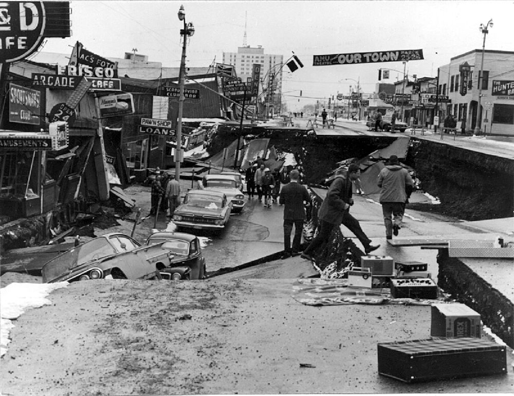
AP-Electric clocks on walls in Anchorage shut down at 5:36 p.m. on March 27, 1964. Time stopped at the start of the ’64 Great Alaska Earthquake, the second largest ever recorded at magnitude 9.2.

The ground shook for four to five minutes, roughly twice through “I Want to Hold Your Hand,” the Beatles No. 1 song that year. With the U.S. and the USSR facing off in the Cold War, some thought the Russians had attacked. The quake produced a tsunami that wreaked havoc along the West Coast. Overall damage was estimated at $2.3 billion in 2014 dollars. The quake and tsunamis killed 131 people.

Though now a distant memory, it helped make experts better prepared for future quakes. It played a role in the formation of the West Coast and Alaska Tsunami Warning Center and taught the U.S. Geological Survey what evidence to look for of previous great quakes, such as events in the Cascadia Subduction Zone off Oregon and Washington.

Geologists have a name for such strong earthquakes — megathrusts.

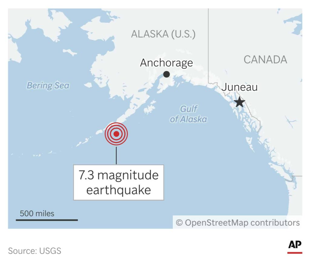
Plate tectonic theory says the Earth’s crust is made up of about a dozen major plates that rest on hot mantle. The thin, dense, Pacific Plate at Alaska’s southern edge moves at a shallow angle beneath the North American Plate at average rate of 2.3 inches (5.8 centimeters) per year and eventually is reabsorbed by mantle. Strain builds up until there’s a slip.

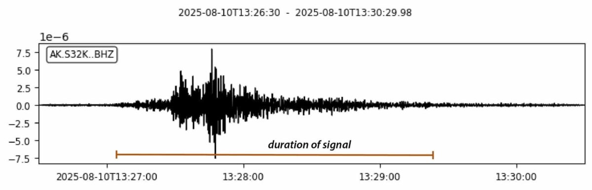
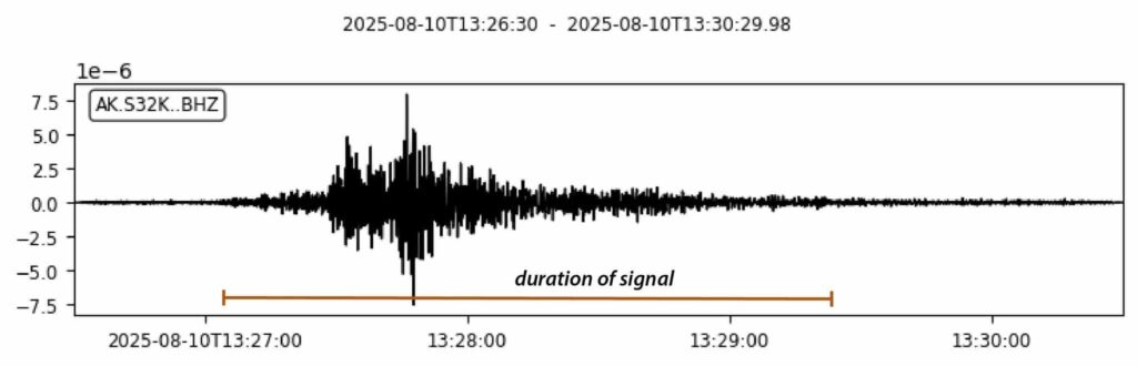
The Moment Magnitude scale rates quakes by the energy they release by calculating the area of fault rupture, the average amount of slip, and the force required to overcome the friction sticking the rocks together, according to the USGS. Every whole number higher on the scale represents 30 times the energy of the previous number.

More energy was released in the 1964 magnitude 9.2 quake than all other recorded Alaska quakes combined, said USGS research geologist Peter Haeussler. And drilling showed evidence of nine such megathrusts in south-central Alaska in 5,500 years. The average time span between them: 600 years.

The temblor caused two kinds of waves: local and trans-ocean tsunamis.

Eighty-five of the 106 Alaska tsunami deaths were caused by waves generated by underwater landslides. Rivers flowing into Alaska fjords build up huge deltas of unstable sediment on deep, underwater slopes, said USGS research geologist Rob Witter. Slides generate waves like a rock dropped in a pond.

During local tsunamis, water can at first retreat from shore in response to the underwater slide, then rush back. That’s what happened at Port Valdez. When the water swept back in, it smashed a freighter into the city dock. Longshoremen and children who had assembled to catch oranges or candy tossed down from the crew were killed. Thirty-two people died.

The great quake also rumpled the ocean floor like a rug, creating a trans-ocean tsunami. The deadly waves traveled down the West Coast. Four campers on a beach died at Newport, Ore. A dozen died in the northern California community of Crescent City.

Categories
Featured Juneau News Juneau Local Ketchikan Local News Feeds Sitka Local

Magnitude-7.0 earthquake hits along Alaska-Canada border

Hubbard Glacier, located near Yakutat, Alaska, is seen on Aug. 1, 2024. (AP Photo/Mark Thiessen)

AP- A powerful, magnitude-7.0 earthquake struck in a remote area near the border between Alaska and the Canadian territory of Yukon on Saturday. There was no tsunami warning, and officials said there were no immediate reports of damage or injury.

The U.S. Geological Survey said it struck about 230 miles (370 kilometers) northwest of Juneau, Alaska, and 155 miles (250 kilometers) west of Whitehorse, Yukon.

In Whitehorse, Royal Canadian Mounted Police Sgt. Calista MacLeod said the detachment received two 911 calls about the earthquake.

“It definitely was felt,” MacLeod said. “There are a lot of people on social media, people felt it.”

Alison Bird, a seismologist with Natural Resources Canada, said the part of Yukon most affected by the temblor is mountainous and has few people.

“Mostly people have reported things falling off shelves and walls,” Bird said. “It doesn’t seem like we’ve seen anything in terms of structural damage.”

The Canadian community nearest to the epicenter is Haines Junction, Bird said, about 80 miles (130 kilometers) away. The Yukon Bureau of Statistics lists its population count for 2022 as 1,018.

The quake was also about 56 miles (91 kilometers) from Yakutat, Alaska, which the USGS said has 662 residents.

It struck at a depth of about 6 miles (10 kilometers) and was followed by multiple smaller aftershocks.

Categories
Featured Juneau News Juneau Local Ketchikan Local News Feeds Sitka Local

Landslide in Southeast Alaska makes waves

Photo provided by the Alaska Earthquake Center

NOTN- A Landslide struck around Endicott Arm, just South of Juneau early Sunday, producing 10 to 15 foot waves according to the Alaska Earthquake Center, they say the waves were observed across the region.

According to the Alaska Earthquake Center the local Tsunami rolled through Endicott Arm just after 5:30 AM following a significant landslide in the region, where several tens of millions of cubic meters of rock struck the water.

No damage or injuries have been reported.

Categories
Featured Juneau News Juneau Local Ketchikan Local News Feeds Sitka Local

An Alaska tsunami warning had residents scrambling for high ground after 7.3 magnitude earthquake

A strong earthquake Wednesday off the Alaska coast triggered a tsunami warning. (AP Graphic)

(AP) — Communities along a 700-mile (1,127-km) stretch of Alaska’s southern coast ordered residents to higher ground after a powerful offshore earthquake Wednesday, but officials quickly downgraded and then canceled a tsunami warning for the region. There were no reports of significant damage.

The earthquake, with a preliminary magnitude of 7.3, struck at 12:37 p.m. local time south of Sand Point, a community of about 600 people on Popof Island, in the Aleutian chain, according to the Alaska Earthquake Center.

There were 40 aftershocks detected within the first three hours, the center said.

“We have seen other earthquakes in the area that have not generated significant tsunami waves, but we’re treating it seriously and going through our procedures, making sure communities are notified so they can activate their evacuation procedures,” said Jeremy Zidek, a spokesperson for Alaska’s emergency management division.

The quake was felt as far away as Anchorage, almost 600 miles (966 km) to the northeast.

The National Tsunami Warning Center issued a warning for an area stretching from about 40 miles (64.4 km) southwest of Homer to Unimak Pass, a distance of about 700 miles (1,126 kilometers). Among the larger communities in the area was Kodiak, with a population of about 5,200. The warning was downgraded to an advisory about an hour later, and canceled just before 2:45 p.m.

The highest water level generated by the earthquake in Sand Point was not quite 2.5 inches (6.3 cm) above the tide, the center said.

“There’s no damage at the airport, doesn’t appear to be any damage at the harbor, no damage to speak of, really,” Sand Point Police Chief Benjamin Allen said.

There was some damage — in the form of broken bottles — at the Alaska Commercial general store in town. Manager Vickey McDonald said about half of the store’s alcohol aisle had crashed and shattered.

“I’ve got liquid smoke and barbecue sauce and pickles … broken on the floor,” McDonald said. “It smells horrendous in here.”

In Unalaska, a fishing community of about 4,100, officials urged people in possible inundation zones to move at least 50 feet above sea level or 1 mile (1.6 km) inland. In King Cove, which has about 870 residents on the south side of the Alaska Peninsula, officials sent an alert calling on those in the coastal area to move to higher ground.

Tourists Jodie Stevens and her husband, Aaron Park, were looking at the puffins at the Alaska SeaLife Center in Seward when they heard someone yelling that there had been an earthquake and they needed to evacuate. They walked a few blocks uphill in the rain, with a woman from the center yelling to those they passed to get to higher ground.

They were about halfway to the official high ground spot when they heard a siren signal that all was clear, she said.

The National Weather Service said in posts on social media that there was no tsunami threat for other U.S. and Canadian Pacific coasts in North America, including Washington, Oregon and California.

Alaska’s southern coast is earthquake-prone, and Wednesday’s was the fifth in roughly the same area since 2020 exceeding magnitude 7, state seismologist Michael West said.

“Something’s moving in this area,” he said. “I would not call this an isolated earthquake. It appears to be part of a larger sequence spanning the last several years.”

That has the attention of seismologists, he said.

“This area has been and remains capable of larger earthquakes and earthquakes capable of significant tsunami damage,” he said.